Troll Resort
Overview
Troll Resort runs on a noticeably different schedule than most ski areas in this dataset: rather than staying open daily through the season, it typically closes Tuesdays and Wednesdays, aside from the Christmas holiday period, and even on operating days it runs a compact 10am-to-4pm lift schedule. That pared-back approach fits its setting. The resort sits along the Barkerville Highway outside Quesnel, deep in British Columbia’s Cariboo gold rush country, a region better known historically for prospectors than for ski tourism, and it has operated here since 1972.
All five of Troll’s lifts, named Yellow, Red, Silver, and Black, are T-bars rather than chairlifts, an unusual setup for a resort of this scale, serving 38 runs across 33.99 kilometers of trail. The mountain drops 518.8 vertical meters from a 1,531.4-meter summit to a 1,012.6-meter base, and the terrain leans genuinely toward experienced skiers: 13.17 kilometers rate advanced, ahead of the 12.0 kilometers intermediate and 7.71 kilometers easy, a steeper overall mix than the resort’s remote, low-key reputation might suggest. Recent years have also brought terrain park expansion alongside the existing steep gladed sections cut through the trees.
No multi-resort pass currently includes Troll Resort, so lift access runs entirely through tickets and passes sold directly at the mountain. Remoteness defines the access picture more than anything else: Quesnel Airport is the nearest airstrip at 38.3 kilometers, but Kamloops, the closest city of meaningful size at roughly 104,460 residents, sits 290.4 kilometers away, and the practical gateway airport in Kelowna is nearly 390 kilometers from the base. That distance from any population center, paired with the limited-days operating schedule, marks Troll as a mountain built for a committed local and regional following rather than for casual destination visitors passing through central British Columbia.
The Barkerville Highway on which the resort sits takes its name from Barkerville itself, a preserved 1860s gold rush settlement farther north along the same route and one of the defining sites of the Cariboo region’s mining history, a legacy that long predates any ski tourism in the area. Season pass buyers at Troll must sign a liability waiver and release agreement as a condition of sale, a formal requirement the resort states plainly in its own terms. Recent seasons have also brought expansion to the terrain park, adding features to complement the existing mix of beginner slopes, groomed cruisers, and the steep gladed tree runs that account for much of the mountain’s advanced terrain. For skiers willing to make the drive into this stretch of interior British Columbia, that combination of real vertical, genuine tree skiing, and a low-key, T-bar-only lift system offers a distinctly old-school alternative to the larger, corporate-owned resorts elsewhere in the province.
All five of Troll’s lifts being T-bars rather than chairs is unusual enough among the resorts covered on this site to be worth underlining: T-bars are cheaper to build and maintain than chairlifts but move skiers more slowly and require a different riding technique, a tradeoff that fits a mountain operating on a limited-day schedule with a smaller visitor base than a major resort. Against a 518.8-meter vertical, the 38-run network works out to about 7.6 runs per lift, and the terrain’s genuinely advanced-leaning mix, more advanced distance than either intermediate or easy, reinforces Troll’s reputation among regional skiers as a mountain with real teeth despite its remote, low-profile position deep in the Cariboo, where the nearest comparable lift-served terrain sits a long drive away in any direction.
Key stats
Official website — Last checked 2026-09-13
Lifts by type
| Type | Count |
|---|---|
| t-bar | 5 |
Runs by difficulty
| Difficulty | Distance |
|---|---|
| easy | 7.71 km |
| other | 0.73 km |
| novice | 0.38 km |
| advanced | 13.17 km |
| intermediate | 12 km |
Maps
Official trail map: see trollresort.com
Run & lift overview
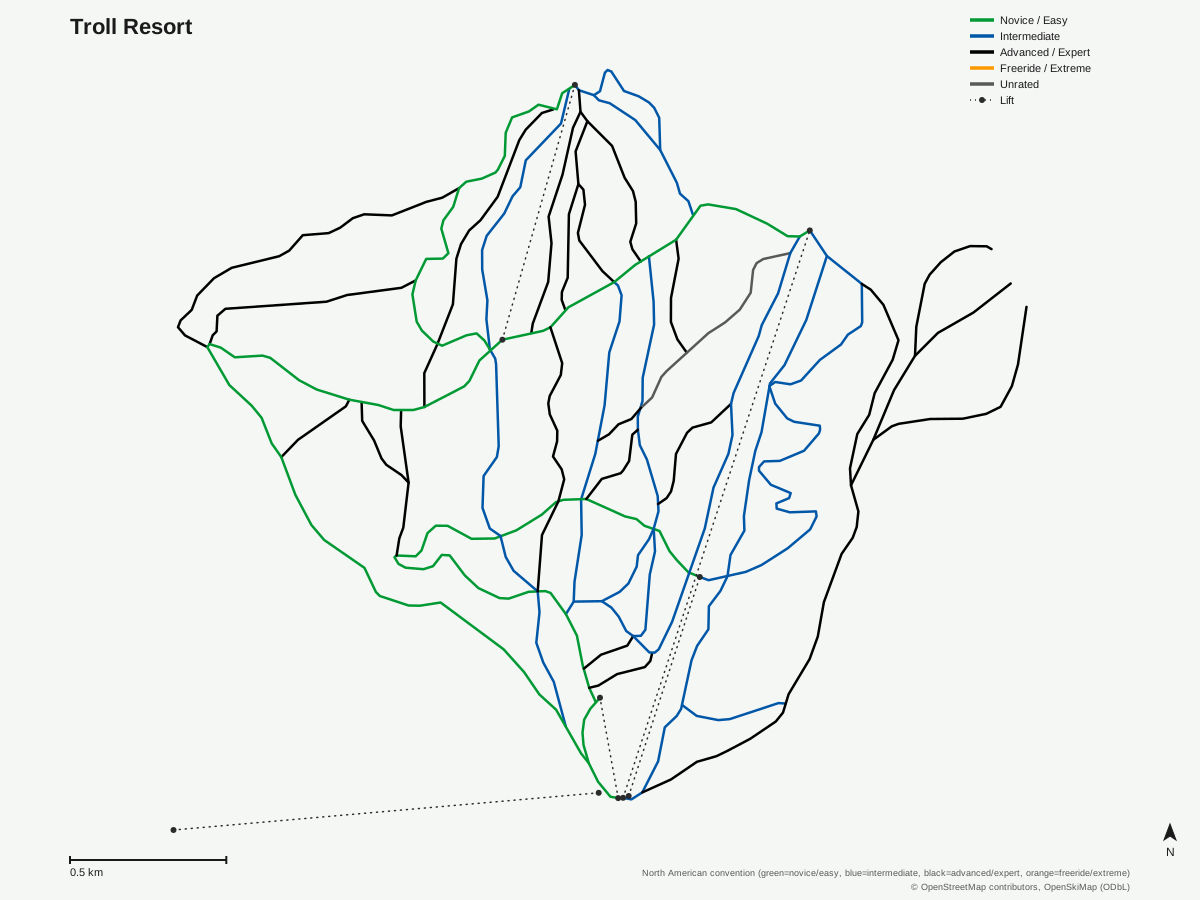
Troll Resort: 38 runs, 5 lifts. A schematic built from OpenStreetMap/OpenSkiMap data — this is not Troll Resort's official trail map. © OpenStreetMap contributors, OpenSkiMap (ODbL).
Typical conditions by month
Monthly conditions data for Troll Resort is not yet available.
Lift tickets & passes
Troll Resort has no multi-resort pass affiliations on record.
Getting there
Nearest airports
- Quesnel Airport (YQZ) — 38.3 km straight-line
- Williams Lake Airport (YWL) — 99.8 km straight-line
- Prince George (International) Airport (YXS) — 101.6 km straight-line
Nearest cities
- Kamloops, British Columbia — 290.4 km straight-line
- Kelowna, British Columbia — 393.8 km straight-line
- Coquitlam, British Columbia — 425.8 km straight-line
Where to stay
A dedicated lodging guide for Troll Resort is not yet available.
Nearby resorts
- Purden Ski Village — 92 km straight-line, 322.6 m vertical
- Tabor Mountain — 102 km straight-line, 237.6 m vertical
- Mount Timothy — 138 km straight-line, 275.4 m vertical
- Marmot Basin — 259 km straight-line, 780.2 m vertical
- Powder King Mountain Resort — 259 km straight-line, 568.7 m vertical
FAQ
- Is Troll Resort open every day?
- No, it typically closes Tuesdays and Wednesdays, aside from the Christmas holiday stretch, and runs lifts from 10am to 4pm on the days it does operate.
- How old is Troll Resort?
- It was established in 1972, on the Barkerville Highway outside Quesnel in British Columbia's historic Cariboo gold rush region.
- How big is Troll Resort?
- A 518.8-meter vertical drop from a 1,531.4-meter summit to a 1,012.6-meter base, with 5 lifts, all T-bars, serving 38 runs across 33.99 kilometers of trail.
- Is Troll Resort good for advanced skiers?
- There's real advanced terrain relative to the resort's size: 13.17 of its 33.99 kilometers of trail rate advanced, ahead of the 12.0 kilometers intermediate and 7.71 kilometers easy.
- Does Troll Resort participate in any multi-resort pass?
- No, it has no multi-resort pass affiliations on record.
- What's the nearest city to Troll Resort?
- Kamloops, British Columbia, population around 104,460, is the closest city of real size, but it's still 290.4 kilometers away, making Troll one of the more remote resorts covered on this site.
- What's the nearest airport to Troll Resort?
- Quesnel Airport is closest at 38.3 kilometers, with Kelowna International Airport, the resort's practical gateway, roughly 389.8 kilometers away.
- Why is the highway to Troll Resort called Barkerville Highway?
- It's named for Barkerville, a preserved 1860s gold rush settlement farther north along the same route, part of the Cariboo region's mining history that predates ski tourism here by roughly a century.
Data sources
Last verified: 2026-09-17
Base facts from OpenSkiMap (ODbL), OpenStreetMap contributors, Wikidata (CC0), OurAirports (public domain) and GeoNames (CC BY 4.0). See /data-sources/.