
Hachi Kita Ski Area
Overview
Six chairlifts for eight runs is a dense ratio by most standards, and at Hachi Kita Ski Area that density comes paired with terrain that skews hard toward the difficult end: 1.95 km of intermediate runs and 1.69 km of advanced runs against just 0.53 km combined of easy and novice grading. In practical terms, fewer than one run in eight at Hachi Kita is aimed at newer skiers, which makes it a compact mountain built more for skiers who already have their legs under them than for a first outing on snow. All six lifts are chairlifts rather than surface tows, and spread across the 4.18 km of trail, that works out to roughly 0.7 km of run length per lift, a low figure that suggests several lifts serve short, dedicated pitches rather than one long connector run.
The resort’s own description of its terrain backs up that picture. Hachi Kita is the “Hachikita” half of a two-area complex it runs jointly with the neighboring Hachi side, and the operator’s site singles out ridge-line cruising runs, an off-piste “nature zone” that opens specifically after fresh snowfall, and mogul terrain on what it calls the north wall, all features aimed at skiers looking for more than groomed corduroy. There is a beginner concession: a dedicated first-timer practice area is listed for the Hachikita side, which softens the terrain skew somewhat even if it doesn’t show up as separate easy-graded mileage in the run totals. Each side of the complex runs its own kids park as well, according to the operator, so families are not limited to a single shared beginner zone. Together, Hachi and Hachikita are promoted by the operator as the largest ski ground in the Kansai region, with two separate resort offices, one in Yabu city serving the Hachi side and one in Kami town serving Hachikita, though that combined-area claim covers both mountains rather than Hachi Kita’s own 8 runs and 484.4 meters of vertical.
From a 732.3-meter base to a 1,216.7-meter summit, Hachi Kita’s 484.4 meters of vertical is respectable for a resort this compact, and it’s delivered over a trail network small enough that a skier could realistically lap every run in a single day. Put another way, roughly 87 percent of the mountain’s 4.18 km of terrain sits in the intermediate or advanced categories, leaving the remaining 13 percent, just 0.53 km, for easier skiing, a split that leans further toward difficult terrain than most resorts of comparable size. Access to the area runs through northern Hyogo Prefecture, roughly 30 minutes by car from the Yabiko Hioyama highway interchange, with the operator noting that a newer expressway link (the Shin-Meishin route) has eased some of the seasonal congestion getting there. The closest airport is Konotori Tajima (TJH), just 25.6 km out, followed by Tottori Sand Dunes Conan (TTJ) at 37.0 km; Okayama Momotaro (OKJ), a larger airport, sits 94.9 km away and doubles as the resort’s listed gateway. By road, Tottori-shi is nearest at 30.0 km, ahead of Tsuyama (62.6 km) and Himeji (66.5 km), all three within striking distance for a day visit. Divide the 4.18 km of total terrain across 8 runs and the average run comes out to about 0.52 km, short, punchy laps consistent with a resort whose personality is set by steep pitch rather than long cruising distance. No multi-resort lift pass is listed for the property, so a ticket here is a standalone purchase rather than part of a bundled regional pass.
Key stats
Official website — Last checked 2026-09-13
Lifts by type
| Type | Count |
|---|---|
| chair lift | 6 |
Runs by difficulty
| Difficulty | Distance |
|---|---|
| easy | 0.3 km |
| novice | 0.23 km |
| advanced | 1.69 km |
| intermediate | 1.95 km |
Maps
View official Hachi Kita Ski Area trail map (PDF) →
Run & lift overview
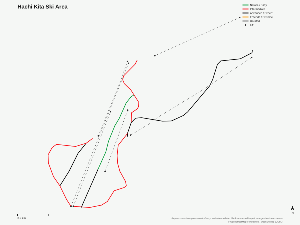
Hachi Kita Ski Area: 8 runs, 6 lifts. A schematic built from OpenStreetMap/OpenSkiMap data — this is not Hachi Kita Ski Area's official trail map. © OpenStreetMap contributors, OpenSkiMap (ODbL).
Typical conditions by month
Monthly conditions data for Hachi Kita Ski Area is not yet available.
Lift tickets & passes
Hachi Kita Ski Area has no multi-resort pass affiliations on record.
Getting there
Nearest airports
- Konotori Tajima Airport (TJH) — 25.6 km straight-line
- Tottori Sand Dunes Conan Airport (TTJ) — 37 km straight-line
- Okayama Momotaro Airport (OKJ) — 94.9 km straight-line
Nearest cities
- Tottori-shi, Tottori — 30 km straight-line
- Tsuyama, Okayama — 62.6 km straight-line
- Himeji, Hyōgo — 66.5 km straight-line
Also covered by
Where to stay
A dedicated lodging guide for Hachi Kita Ski Area is not yet available.
Nearby resorts
- Hachikogen Ski Resort — 1 km straight-line, 360.4 m vertical
- Mikata Snow Park — 1 km straight-line, 455.2 m vertical
- Hyper Bowl Tohachi — 2 km straight-line, 367.2 m vertical
- Sky Valley Ski Area — 2 km straight-line, 455.8 m vertical
- Hyounosen Kokusai Ski Resort — 4 km straight-line, 337 m vertical
FAQ
- How many runs and lifts does Hachi Kita Ski Area have?
- 8 runs served by 6 chairlifts, totaling 4.18 km of skiable terrain. That works out to roughly 0.7 km of run length per lift, well below what a single lift typically covers at a larger resort.
- Is Hachi Kita Ski Area good for beginners?
- Terrain is limited for newer skiers: easy and novice runs together add up to only 0.53 km, about 13 percent of the mountain, against 3.64 km (87 percent) of intermediate and advanced terrain. The operator's site does list a dedicated first-timer practice area at the Hachikita side, which helps offset the thin easy-graded mileage.
- What is the vertical drop at Hachi Kita?
- 484.4 meters, from a 732.3-meter base to a 1,216.7-meter summit. That's a comparable vertical to several other mid-sized resorts in this region, delivered over a compact 4.18 km trail network.
- Is Hachi Kita connected to another ski area?
- Yes. It operates alongside the neighboring Hachi area as the combined Hachi-Hachikita ski ground, which the operator's site markets as the largest ski area in the Kansai region, with two separate base offices serving each side.
- Does Hachi Kita have off-piste or ungroomed terrain?
- The operator's site describes a designated off-piste 'nature zone' that opens after fresh snowfall, plus mogul terrain on a section referred to as the north wall. Both are pitched at skiers past the beginner stage, reinforcing the area's intermediate-to-advanced skew.
- What's the nearest airport to Hachi Kita Ski Area?
- Konotori Tajima Airport (TJH), about 25.6 km away. Tottori Sand Dunes Conan Airport (TTJ) is 37.0 km, and Okayama Momotaro Airport (OKJ), a larger gateway, is 94.9 km.
- What's the nearest city to Hachi Kita Ski Area?
- Tottori-shi, roughly 30.0 km away, with Tsuyama at 62.6 km and Himeji at 66.5 km. All three sit in the Tottori-Hyogo-Okayama corridor that feeds most of the resort's regional traffic.
- Does Hachi Kita Ski Area accept a multi-resort lift pass?
- No pass affiliation is listed in the resort's records; tickets appear to be sold directly by the operator. That matches the pattern for most standalone resorts of this size in northern Hyogo Prefecture.
Data sources
Last verified: 2026-09-15
Base facts from OpenSkiMap (ODbL), OpenStreetMap contributors, Wikidata (CC0), OurAirports (public domain) and GeoNames (CC BY 4.0). See /data-sources/.