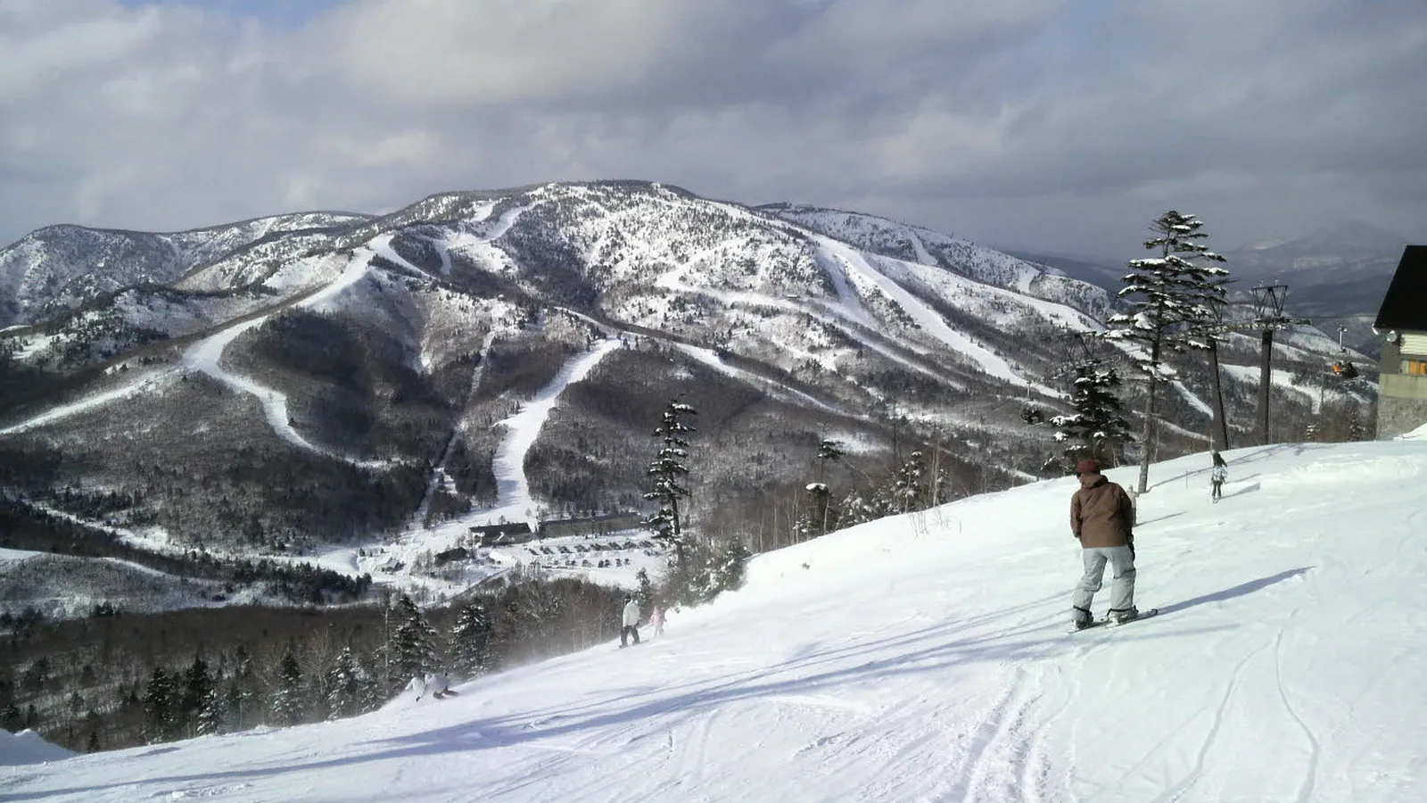
Shiga Kogen Yakebitaiyama Ski Area
Overview
Shiga Kogen Yakebitaiyama Ski Area sits higher than any other resort in this comparison set: a 1,548.1-meter base and a 1,997.9-meter summit, just shy of the 2,000-meter mark, connected by two gondolas and three chairlifts. That gondola pairing is unusual for a resort of this size and points to sustained skier traffic up a long vertical face, even though the net vertical drop, 449.8 meters, is comparable to several lower-elevation resorts nearby. Across those five lifts and 22 runs, the record works out to about 3.3 kilometers of piste per lift, well above the per-lift figures at the smaller Hyogo-area resorts in this batch, and an average run length of roughly 750 meters.
Yakebitaiyama is one of several distinct ski sectors within the wider Shiga Kogen area in Nagano Prefecture – the operator’s own site lists it alongside Oku-Shiga, the central zone, Kumayu, and the Yokoteyama/Shibutoge sector as separate pieces of a much larger regional network, and names Shiga Kogen Resort Development as the company running the interconnected gondola systems across that network. This record covers only the Yakebitaiyama piste data specifically, not the combined statistics of the full multi-zone Shiga Kogen complex that regularly appears on best-of-Japan lists.
On the mountain itself, 22 mapped runs cover 16.51 kilometers, weighted toward intermediate terrain at 9.22 km (roughly 56 percent of the total), with 4.93 km rated easy (about 30 percent) and 2.35 km advanced (about 14 percent) – a spread that favors skiers who want sustained, moderately pitched cruising over short beginner loops or narrow expert lines. Unlike Blanche Takayama or Sky Valley elsewhere in this batch, the record shows no novice- or “other”-graded terrain here, just the standard three-tier split. That intermediate-heavy mix, combined with the altitude, suggests more reliable snow quality deeper into the season than lower resorts in this same batch can offer.
Access leans toward Niigata rather than Nagano despite the Nagano Prefecture address: Niigata Airport, 143.8 kilometers out, is the listed gateway, ahead of Toyama Kitokito at 118.9 kilometers and Shinshu-Matsumoto at 83.9 kilometers, the closest of the three – a full 59.9 kilometers nearer than the formal gateway airport. Nagano city itself is much closer by road, at 31.6 kilometers, with Ueda and Joetsu following at 44.0 and 50.6 kilometers. The record carries no pass affiliation for Yakebitaiyama specifically, so visitors should confirm current pass coverage directly, especially given how many separate operators run lifts across the broader Shiga Kogen region. The resort’s coordinates, roughly 36.75 degrees north and 138.51 degrees east, place it in the mountainous interior of Nagano Prefecture, and the operator’s site was last checked for trail-map and lift-status accuracy on September 13, 2026, with the current map published as a downloadable PDF rather than a static image.
Key stats
Official website — Last checked 2026-09-13
Lifts by type
| Type | Count |
|---|---|
| gondola | 2 |
| chair lift | 3 |
Runs by difficulty
| Difficulty | Distance |
|---|---|
| easy | 4.93 km |
| advanced | 2.35 km |
| intermediate | 9.22 km |
Maps
View official Shiga Kogen Yakebitaiyama Ski Area trail map (PDF) →
Run & lift overview
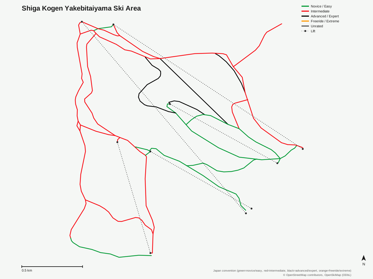
Shiga Kogen Yakebitaiyama Ski Area: 22 runs, 5 lifts. Reflects OpenStreetMap's run and lift mapping for Shiga Kogen Yakebitaiyama Ski Area, not the resort's own trail map graphic. © OpenStreetMap contributors, OpenSkiMap (ODbL).
Typical conditions by month
Monthly conditions data for Shiga Kogen Yakebitaiyama Ski Area is not yet available.
Lift tickets & passes
Shiga Kogen Yakebitaiyama Ski Area has no multi-resort pass affiliations on record.
Getting there
Nearest airports
- Shinshu-Matsumoto Airport (MMJ) — 83.9 km straight-line
- Toyama Kitokito Airport (TOY) — 118.9 km straight-line
- Niigata Airport (KIJ) — 143.8 km straight-line
Nearest cities
- Nagano, Nagano — 31.6 km straight-line
- Ueda, Nagano — 44 km straight-line
- Jōetsu, Niigata — 50.6 km straight-line
Also covered by
Where to stay
A dedicated lodging guide for Shiga Kogen Yakebitaiyama Ski Area is not yet available.
Nearby resorts
- Shiga Kogen — 2 km straight-line, 971.6 m vertical
- Shiga Kogen Ichinose Family Ski Area — 2 km straight-line, 327.1 m vertical
- Shiga Kogen Okushiga Kogen Ski Area — 2 km straight-line, 524.8 m vertical
- Shiga Kogen Takamagahara Mammoth Ski Area — 2 km straight-line, 232.3 m vertical
- Shiga Kogen Nishidateyama Ski Area — 3 km straight-line, 359.4 m vertical
FAQ
- How high is Shiga Kogen Yakebitaiyama Ski Area?
- It rises from a 1,548.1-meter base to a 1,997.9-meter summit, the highest base elevation of any resort in this comparison set. The 449.8-meter vertical drop between those points is actually comparable to several lower-based resorts in the same batch, since the mountain simply starts and ends higher.
- Is Yakebitaiyama the same as the famous Shiga Kogen ski resort?
- No. Yakebitaiyama is one of several distinct ski sectors within the larger Shiga Kogen area -- the operator's own site lists it separately from the Oku-Shiga, central, Kumayu, and Yokoteyama/Shibutoge zones. This record covers only Yakebitaiyama's own terrain and lifts, not the combined statistics of the full multi-zone complex.
- What lifts does Yakebitaiyama have?
- Two gondolas and three chairlifts, five lifts in total, serving 22 mapped runs. That's about 3.3 kilometers of piste per lift, a notably high figure compared with the smaller resorts elsewhere in this batch.
- Is Yakebitaiyama good for intermediate skiers?
- Yes, intermediate terrain dominates at 9.22 of the 16.51 total kilometers, roughly 56 percent of the mountain, with 4.93 km easy and 2.35 km advanced. The record shows no novice- or 'other'-graded terrain here, just the standard three-tier split.
- What's the nearest airport to Yakebitaiyama?
- Shinshu-Matsumoto Airport is closest at 83.9 kilometers, though the record lists Niigata Airport, 143.8 kilometers away, as the formal gateway; Toyama Kitokito sits in between at 118.9 kilometers. The nearest airport and the listed gateway differ by nearly 60 kilometers.
- How many runs are at Yakebitaiyama and how long are they?
- 22 runs covering 16.51 kilometers in total, for an average run length of about 750 meters. That total distance is the longest of any resort in this comparison set.
- Which city is closest to Yakebitaiyama?
- Nagano city, 31.6 kilometers away, ahead of Ueda at 44.0 kilometers and Joetsu at 50.6 kilometers. All three are considerably closer than any of the three listed airports.
- Is there advanced terrain at Yakebitaiyama?
- Yes, 2.35 kilometers is rated advanced, about 14 percent of the mountain's total distance, though the terrain leans much more heavily toward the 9.22 kilometers of intermediate piste.
Data sources
Last verified: 2026-09-15
Base facts from OpenSkiMap (ODbL), OpenStreetMap contributors, Wikidata (CC0), OurAirports (public domain) and GeoNames (CC BY 4.0). See /data-sources/.