Kagura Area
Overview
Kagura Area sits at 1,322.3 meters of base elevation in Niigata Prefecture, climbing to a 1,837.7-meter summit for 515.4 meters of vertical, served by five lifts, a gondola and four chairlifts, across 15 runs and 8.7 kilometers of mapped terrain. That’s a compact footprint compared to the largest Japanese ski areas, but the lift count relative to run count, five lifts for 15 runs, suggests a mountain where most terrain is directly and efficiently lift-served rather than spread across long traverses.
The terrain mix favors skiers who have moved past the beginner stage: 3.56 kilometers of intermediate runs form the largest single category, ahead of 2.81 kilometers of advanced terrain and 2.33 kilometers of easy runs. There’s no novice or expert-specific category recorded in Kagura’s run breakdown, which points to a mountain built around a solid intermediate-to-advanced core rather than one stretched to cover every ability level.
Kagura’s location in Niigata puts it within striking distance of three prefectures at once. Jōetsu, with a population around 189,400, is the closest listed city at 53.5 kilometers, followed closely by Nagano city (372,800 people, 54.1 kilometers) and Maebashi in Gunma (332,100 people, 61 kilometers). For air travel, Shinshu-Matsumoto Airport is nominally closest at 106 kilometers, though Niigata Airport, 125.5 kilometers out, is listed as the resort’s primary gateway, likely reflecting better connections for international visitors heading to this corner of the Japanese Alps.
There’s no multi-resort pass listed against Kagura Area in the available data, which means visitors should expect to buy lift tickets directly rather than relying on Ikon, Epic, or a regional Japanese pass product to cover it. Combined with its position roughly equidistant from Niigata, Nagano, and Gunma prefectures, Kagura reads as a resort suited to travelers already based somewhere in that tri-prefecture corridor rather than one built around a single obvious gateway city.
Looked at as a set of ratios rather than raw totals, Kagura’s numbers describe a mountain built for efficient, repeated laps rather than long exploratory descents. Average run length comes out to roughly 0.58 kilometers, and vertical per lift works out to about 103 meters across the five-lift system, on the higher end for a mountain this compact, meaning each of Kagura’s lifts covers more ground per ride than the run count alone might suggest. With no easy category topping out the terrain chart and no dedicated expert-rated runs recorded either, the mountain’s character sits squarely in the intermediate-to-advanced middle, a profile that rewards skiers already comfortable linking turns on ungroomed pitches rather than those still working on the basics.
Kagura’s elevation profile, a 1,322.3-meter base rising to 1,837.7 meters, is high enough by Japanese ski-area standards that the gondola, the sole non-chairlift in its five-lift system, likely covers a longer base-to-mid-mountain haul than a chairlift alone would handle, consistent with the summit sitting more than 500 meters above the base. None of that changes the core numbers, a 515.4-meter vertical drop and 8.7 kilometers of runs, but the tri-prefecture access data, roughly an hour or less to Jōetsu, Nagano, or Maebashi, shows a resort positioned to draw skiers from three separate regional population centers rather than depending on any single feeder city the way many smaller Japanese areas do.
Key stats
Official website — Last checked 2026-09-14
Lifts by type
| Type | Count |
|---|---|
| gondola | 1 |
| chair lift | 4 |
Runs by difficulty
| Difficulty | Distance |
|---|---|
| easy | 2.33 km |
| advanced | 2.81 km |
| intermediate | 3.56 km |
Maps
View official Kagura Area trail map (page) →
Run & lift overview
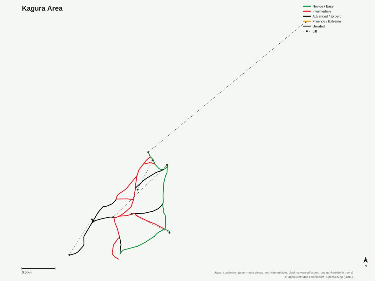
Kagura Area: 15 runs, 5 lifts. A schematic built from OpenStreetMap/OpenSkiMap data — this is not Kagura Area's official trail map. © OpenStreetMap contributors, OpenSkiMap (ODbL).
Typical conditions by month
Monthly conditions data for Kagura Area is not yet available.
Lift tickets & passes
Kagura Area has no multi-resort pass affiliations on record.
Getting there
Nearest airports
- Shinshu-Matsumoto Airport (MMJ) — 106 km straight-line
- Niigata Airport (KIJ) — 125.5 km straight-line
- Sado Airport (SDS) — 135.4 km straight-line
Nearest cities
- Jōetsu, Niigata — 53.5 km straight-line
- Nagano, Nagano — 54.1 km straight-line
- Maebashi, Gunma — 61 km straight-line
Also covered by
Where to stay
A dedicated lodging guide for Kagura Area is not yet available.
Nearby resorts
- Kandatsu Kogen Ski Resort — 8 km straight-line, 500.5 m vertical
- NASPA Ski Garden — 9 km straight-line, 251.9 m vertical
- Naeba Ski Resort — 9 km straight-line, 903.2 m vertical
- Gala Yuzawa Snow Resort — 10 km straight-line, 820.5 m vertical
- New Greenpia Tsunan — 10 km straight-line, 306 m vertical
FAQ
- How big is Kagura Area?
- 515.4 vertical meters between a 1,837.7-meter summit and a 1,322.3-meter base, with 5 lifts, a gondola plus four chairlifts, serving 15 runs across 8.7 mapped kilometers.
- Is Kagura good for intermediate skiers?
- Intermediate terrain is the largest single category at 3.56 kilometers, ahead of 2.81 kilometers advanced and 2.33 kilometers easy, so the mountain leans toward skiers past the beginner stage without being an expert-only area.
- What's the nearest airport to Kagura Area?
- Shinshu-Matsumoto Airport is closest at 106 kilometers, with Niigata Airport at 125.5 kilometers serving as the resort's listed gateway airport.
- Which cities are near Kagura Area?
- Jōetsu (population about 189,400) is 53.5 kilometers away, Nagano (population about 372,800) is 54.1 kilometers, and Maebashi (population about 332,100) is 61 kilometers, putting Kagura within reach of three different prefectures.
- Does Kagura Area have a season pass or multi-resort pass?
- No pass affiliation is listed in the resort's data record, so lift tickets appear to be sold on a standalone basis rather than through a regional or national pass network.
- How many lifts does Kagura Area have?
- Five: one gondola and four chairlifts, a relatively lift-dense setup for a mountain with only 15 mapped runs.
- How long is the average run at Kagura Area?
- The 8.7 kilometers of mapped terrain spread across 15 runs works out to roughly 0.58 kilometers per run, a fairly compact average length.
- How much vertical does each lift at Kagura Area cover?
- 515.4 meters of vertical spread across five lifts works out to about 103 meters per lift, one of the higher per-lift vertical figures among comparably sized areas in the region.
Data sources
Last verified: 2026-09-17
Base facts from OpenSkiMap (ODbL), OpenStreetMap contributors, Wikidata (CC0), OurAirports (public domain) and GeoNames (CC BY 4.0). See /data-sources/.