
Sierra-at-Tahoe Ski Resort
Overview
Sierra-at-Tahoe traces its roots to 1946, when brothers Ray and Floyd Barrett opened it as Sierra Ski Ranch near Twin Bridges, California. The California Department of Transportation’s widening of U.S. Route 50 forced a relocation in 1968, and the resort has operated from its current site in the Eldorado National Forest ever since, now running 13 lifts, nine chairlifts and four magic carpets, over 41 runs totaling 27.15 kilometers, with a 662.7-meter vertical drop between a 2,692.9-meter summit and a 2,030.2-meter base.
Ownership has changed several times since Vern Sprock ran the resort from 1953 to 1993, passing through Fibreboard, then Booth Creek Ski Resorts in 1996, CNL Lifestyle in 2007, and Och-Ziff Capital Management in 2016. Through those changes the terrain identity has stayed consistent: 11.24 kilometers rated easy, the largest category, ahead of 9.3 kilometers intermediate and 6.61 kilometers advanced, a mix that has earned the resort a reputation as one of the more family-oriented options among the resorts ringing the south shore of Lake Tahoe, alongside Kirkwood and Heavenly.
That family orientation hasn’t come at the expense of snow: Sierra-at-Tahoe has historically reported around 480 inches of snowfall a year, a total on the higher end for the southern Tahoe basin, which helps explain why the Ikon Pass, 7 no-blackout days, and the Ikon Base Pass, 5 days with blackout dates, both include it as a destination.
Truckee Tahoe Airport is the nearest air option at 58.2 kilometers, with Reno-Tahoe International a larger commercial alternative at 82.4 kilometers and Sacramento International farther out at 131.8 kilometers. Reno itself, population around 264,000, edges out Roseville and Elk Grove as the closest listed city at 84.5 kilometers. With 13 lifts serving 41 runs, roughly 3.2 runs per lift, Sierra-at-Tahoe carries a denser lift network relative to its trail count than many comparably sized resorts, a legacy of its 1968 relocation onto a site built with lift access as a priority from the start.
The resort’s longest run, Sugar ’n Spice, stretches about 2.5 miles from the upper mountain down toward the base lodge, a long, rolling descent characteristic of a trail network built more around wide, connected pistes than short, steep pitches. Six dedicated terrain parks give the mountain a strong freestyle presence alongside its family-oriented groomed runs, a combination that has helped Sierra-at-Tahoe hold onto a loyal local following even as ownership of the property has changed roughly every decade since the 1990s. Its position within the Eldorado National Forest, a short enough drive from South Lake Tahoe and Stateline, Nevada to work as a day trip, has also made it a common secondary stop for visitors staying near the lake’s larger casino and resort strip but looking for a quieter, less crowded mountain than some of the bigger-name Tahoe resorts closer to the shoreline itself.
Reno-Tahoe International, 82.4 kilometers away, gives out-of-state visitors a workable fly-in option even though Truckee Tahoe Airport sits closer at 58.2 kilometers, and Sacramento International rounds out the choices at 131.8 kilometers for travelers connecting from farther afield in Northern California. That range of airport options, paired with Ikon Pass access shared with dozens of other North American resorts, has kept Sierra-at-Tahoe firmly in the conversation for Tahoe-area ski trips even as it has changed hands repeatedly since Vern Sprock’s original decades-long ownership ended in the early 1990s.
Key stats
Official website — Last checked 2026-09-13
Lifts by type
| Type | Count |
|---|---|
| chair lift | 9 |
| magic carpet | 4 |
Runs by difficulty
| Difficulty | Distance |
|---|---|
| easy | 11.24 km |
| advanced | 6.61 km |
| intermediate | 9.3 km |
Maps
View official Sierra-at-Tahoe Ski Resort trail map (page) →
Run & lift overview
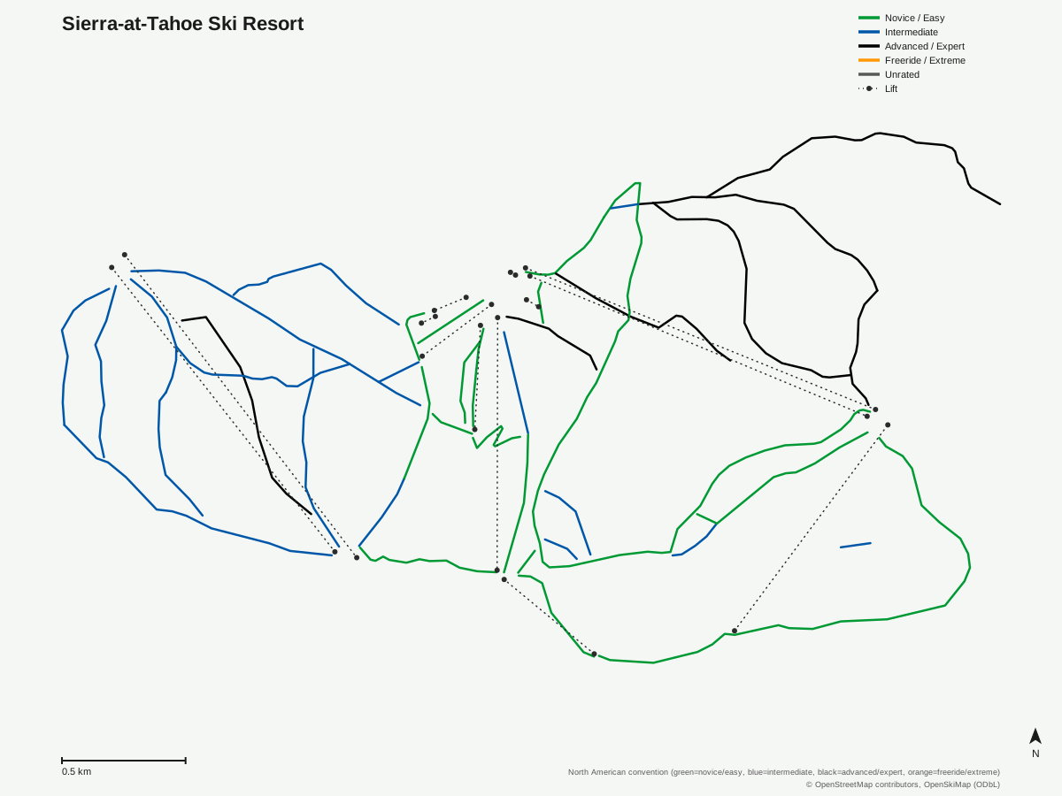
Sierra-at-Tahoe Ski Resort: 41 runs, 13 lifts. Generated from community-mapped OpenStreetMap data, not Sierra-at-Tahoe Ski Resort's official map artwork. © OpenStreetMap contributors, OpenSkiMap (ODbL).
Typical conditions by month
Monthly conditions data for Sierra-at-Tahoe Ski Resort is not yet available.
Lift tickets & passes
- Ikon Pass — 7 days, no blackout
- Ikon Base Pass — 5 days, blackout dates apply
Getting there
Nearest airports
- Truckee Tahoe Airport (TKF) — 58.2 km straight-line
- Reno Tahoe International Airport (RNO) — 82.4 km straight-line
- Sacramento International Airport (SMF) — 131.8 km straight-line
Nearest cities
- Reno, Nevada — 84.5 km straight-line
- Roseville, California — 105.1 km straight-line
- Elk Grove, California — 120.5 km straight-line
Also covered by
Where to stay
A dedicated lodging guide for Sierra-at-Tahoe Ski Resort is not yet available.
Nearby resorts
- Kirkwood Mountain Resort — 13 km straight-line, 504.9 m vertical
- Homewood Ski Area — 32 km straight-line, 499.6 m vertical
- Bear Valley — 35 km straight-line, 558.7 m vertical
- Palisades Tahoe Alpine Meadows — 42 km straight-line, 499 m vertical
- Palisades Tahoe Olympic Valley — 46 km straight-line, 773.8 m vertical
FAQ
- How big is Sierra-at-Tahoe Ski Resort?
- 662.7 vertical meters from a 2,692.9-meter summit to a 2,030.2-meter base, with 13 lifts serving 41 runs across 27.15 kilometers of trail.
- Is Sierra-at-Tahoe good for beginners?
- Yes, 11.24 of the resort's 27.15 kilometers are rated easy, the largest single category, ahead of 9.3 kilometers intermediate and 6.61 kilometers advanced.
- How did Sierra-at-Tahoe start?
- Brothers Ray and Floyd Barrett founded it in 1946 as Sierra Ski Ranch; the resort relocated in 1968 after Caltrans widened U.S. Route 50 through its original site.
- Which passes cover Sierra-at-Tahoe?
- The Ikon Pass includes 7 days with no blackout dates, and the Ikon Base Pass includes 5 days with blackout dates.
- What's the nearest airport to Sierra-at-Tahoe?
- Truckee Tahoe Airport is closest at 58.2 kilometers, ahead of Reno-Tahoe International at 82.4 kilometers.
- Is Sierra-at-Tahoe a family-friendly resort?
- Yes, it's often described as one of the more family-oriented resorts on the south shore of Lake Tahoe, alongside neighbors Kirkwood and Heavenly.
- How much snow does Sierra-at-Tahoe get?
- Historically around 480 inches annually, among the higher snowfall totals of the southern Tahoe resorts.
- What's the nearest city to Sierra-at-Tahoe?
- Reno, Nevada, population around 264,000, is the closest listed city at 84.5 kilometers, just ahead of Roseville and Elk Grove in California.
Data sources
Last verified: 2026-09-17
Base facts from OpenSkiMap (ODbL), OpenStreetMap contributors, Wikidata (CC0), OurAirports (public domain) and GeoNames (CC BY 4.0). See /data-sources/.