
Lookout Pass
Overview
Lookout Pass sits directly on the Idaho-Montana state line along Interstate 90, a location distinctive enough that it’s arguably the resort’s defining feature before you even get to the skiing. It started in 1935 as a volunteer-run community ski hill under the nonprofit Idaho Ski Club, and stayed rope-tow and T-bar territory for decades before its first chairlift arrived in the summer of 1982. Ownership has changed twice since — to Lookout Recreation, Inc. in 1992, then Lookout Associates in 1999 — but the resort has kept its low-key, community-hill character even as it’s grown.
That growth has been real. Terrain expansions on the Montana side in 2003 and the Idaho side in 2006 pushed the base area lower and added acreage, and a December 2022 expansion onto Eagle Peak brought 14 new trails and roughly 500 additional acres, tilting the resort’s balance further toward advanced skiing. Today Lookout Pass runs 56 trails over 37.23 kilometers, dropping 500.9 meters from Eagle Peak’s 1,875-meter summit, with a fairly even split between 18.86 km of intermediate terrain and 12.55 km advanced. Average annual snowfall exceeds 400 inches, a genuinely high number for a resort this size and this far from the coastal Cascades snow belt.
Skiing a resort that straddles a state border also means the mountain’s two flanks have distinct expansion histories baked into the terrain itself — the Montana side developed first in the 2003 expansion, the Idaho side following in 2006 — so longtime visitors sometimes describe the two sides of the hill as having slightly different characters even though they now operate as a single connected ski area.
In summer, Lookout Pass runs double duty as the primary staging area for the Route of the Hiawatha, a 15-mile downhill mountain bike trail built along a historic rail line through tunnels and over trestles — a rare case of a small ski hill having an equally well-known warm-weather attraction. Getting there means driving I-90 regardless of season: the resort sits roughly 5 miles east of Mullan, Idaho, about 56 miles from Coeur d’Alene, and 90 miles from Spokane. Pullman-Moscow Regional Airport is the nearest airfield at about 132 kilometers, with Spokane International slightly farther at 138 kilometers but offering more commercial flight options for out-of-region visitors.
Lookout Pass’s 500.9-meter vertical drop, about 1,643 feet, is modest next to the bigger Rocky Mountain resorts covered elsewhere in this guide, but its more-than-400-inch average annual snowfall rivals or exceeds totals posted by much larger, better-known destinations. That snowfall-to-size ratio, combined with the novelty of skiing a mountain that literally straddles a state line, gives Lookout Pass a distinct identity among the smaller regional resorts in the Inland Northwest — closer in spirit to a dedicated snow-chasing destination than to a typical small community hill, even though it started out exactly as the latter back in 1935.
Visitors planning a Route of the Hiawatha trip in summer and a ski trip in winter effectively get two separate reasons to know Lookout Pass, which is unusual for a resort of its size; most small community ski hills in the Inland Northwest don’t carry a comparably well-known warm-weather attraction alongside their winter operations.
Key stats
Official website — Last checked 2026-09-13
Lifts by type
| Type | Count |
|---|---|
| chair lift | 5 |
Runs by difficulty
| Difficulty | Distance |
|---|---|
| easy | 5.37 km |
| other | 0.45 km |
| advanced | 12.55 km |
| intermediate | 18.86 km |
Maps
View official Lookout Pass trail map (PDF) →
Run & lift overview
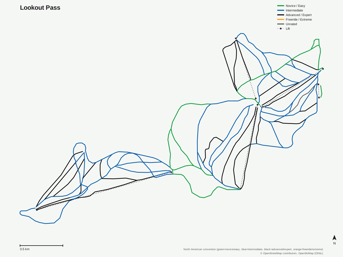
Lookout Pass: 56 runs, 5 lifts. A schematic built from OpenStreetMap/OpenSkiMap data — this is not Lookout Pass's official trail map. © OpenStreetMap contributors, OpenSkiMap (ODbL).
Typical conditions by month
Monthly conditions data for Lookout Pass is not yet available.
Lift tickets & passes
Lookout Pass has no multi-resort pass affiliations on record.
Getting there
Nearest airports
- Pullman-Moscow Regional Airport (PUW) — 132.1 km straight-line
- Missoula Montana Airport (MSO) — 136.4 km straight-line
- Spokane International Airport (GEG) — 137.9 km straight-line
Nearest cities
- Spokane, Washington — 130.7 km straight-line
- Tri-Cities, Washington — 296.8 km straight-line
- Lethbridge, Alberta — 328.3 km straight-line
Also covered by
Where to stay
A dedicated lodging guide for Lookout Pass is not yet available.
Nearby resorts
- Silver Mountain Resort — 32 km straight-line, 631.9 m vertical
- Mt. Spokane — 117 km straight-line, 601.6 m vertical
- Blacktail Mountain Ski Area — 119 km straight-line, 432.9 m vertical
- Schweitzer Mountain Resort — 124 km straight-line, 728 m vertical
- Montana Snowbowl — 138 km straight-line, 773.6 m vertical
FAQ
- Where exactly is Lookout Pass?
- Right on the Idaho-Montana border along Interstate 90, in Shoshone County, Idaho and Mineral County, Montana — the state line runs through the ski area itself, a genuine rarity among American resorts.
- How big is Lookout Pass?
- It has 56 runs across 37.23 km, a 500.9 m vertical drop between an 1,875.0 m summit and a 1,374.1 m base, served by 5 chairlifts, spread across two states' worth of terrain.
- How much snow does Lookout Pass get?
- Over 400 inches a year on average, among the higher snowfall totals of any resort in the Inland Northwest, and a major reason the area has grown from a volunteer-run hill into a genuine regional destination.
- When did Lookout Pass open?
- It started in 1935 as a community ski hill run by the nonprofit Idaho Ski Club, decades before its first chairlift went in during 1982; ownership passed to Lookout Recreation, Inc. in 1992 and Lookout Associates in 1999.
- Is Lookout Pass good for advanced skiers?
- It's fairly balanced — 18.86 km intermediate, 12.55 km advanced, and 5.37 km easy — but the 2022 Eagle Peak expansion specifically added more advanced terrain and roughly 500 acres, tilting recent growth toward steeper skiing.
- What else is Lookout Pass known for?
- It's the main trailhead for the Route of the Hiawatha, a 15-mile downhill mountain bike rail-trail through historic tunnels and trestles that runs in the summer, giving the resort a genuine warm-weather identity beyond skiing.
- What's the nearest city to Lookout Pass?
- Spokane, Washington, at about 138 km, though Coeur d'Alene, Idaho is closer in practice at roughly 56 miles along I-90.
- What's the nearest airport to Lookout Pass?
- Pullman-Moscow Regional Airport, about 132 km away, with Spokane International Airport a close second at 138 km and generally more flight options for visitors flying in from farther away.
Data sources
Last verified: 2026-09-15
Base facts from OpenSkiMap (ODbL), OpenStreetMap contributors, Wikidata (CC0), OurAirports (public domain) and GeoNames (CC BY 4.0). See /data-sources/.