
Geihoku Kokusai
Overview
Geihoku Kokusai sits in the cluster of resorts northern Hiroshima Prefecture runs near the Shimane border, an area the region’s own tourism material describes as home to eight ski areas reachable within one to two hours of Hiroshima city — close enough that a day trip from a metro area of over a million people is a realistic plan rather than a stretch. Hiroshima itself is just 39.9 kilometers away, with Hatsukaichi (41 km) and Higashihiroshima (57.3 km) not much farther, making Geihoku Kokusai one of the more urban-adjacent resorts in this comparison set for a country where many ski areas sit hours from the nearest large city.
The mountain itself climbs 419.3 meters of vertical from a 697.4-meter base to a 1,116.7-meter summit, with six chairlifts serving 15 runs over 9.77 kilometers of terrain. The distribution skews toward the middle and lower end of difficulty: 3.36 km is graded novice, the largest single category, followed by 3.44 km intermediate and 2.51 km advanced, with only a thin 0.46 km specifically marked easy — worth knowing if you’re used to resorts drawing a sharper line between “easy” and “novice” terrain.
Like other resorts in this part of western Japan, the ski season here typically runs from December into March, though some resorts in the cluster open as early as November using artificial snowmaking to bridge the gap before natural snowfall arrives in volume — a practical necessity this far south and at these elevations compared to the deeper, more reliable snowpack of Japan’s Sea of Japan coast resorts further north.
Getting there means flying into Iwami Airport, the closest option at 40.1 kilometers, or Iwakuni Kintaikyo Airport at 62.5 kilometers; Hiroshima Airport, 70.2 kilometers out, is the larger facility and the resort’s designated regional gateway despite not being the nearest. There’s no multi-resort pass tied to Geihoku Kokusai, so a lift ticket is purchased on its own. For skiers based in or flying through Hiroshima without a full week to spend on snow, the combination of short driving distance and a real, if modestly sized, terrain network makes Geihoku Kokusai a practical regional option rather than a destination resort in its own right.
Measured against its closest regional peers in this dataset, Geihoku Kokusai actually edges out both Osorakan Snow Park and Utopia Saioto on vertical drop, at 419.3 meters against 392.2 m and 405.9 m respectively, while running neck-and-neck with Osorakan on total terrain volume. Its six chairlifts work out to roughly 1.6 kilometers of trail per lift, in line with the compact, tightly built layout typical of this part of the Geihoku ski cluster. The resort’s run and lift positions are also mapped through OpenStreetMap and OpenSkiMap and listed on skimap.org, giving visitors an independent way to check terrain layout before making the drive up from Hiroshima.
Hiroshima Airport is the only large airport among the resort’s three nearest options; Iwami and Iwakuni Kintaikyo are both classed as medium airports, which is part of why Hiroshima Airport holds the resort’s official gateway designation despite being the farthest of the three. On the ground, Hiroshima city’s population of 1,200,754 dwarfs both Hatsukaichi (114,173) and Higashihiroshima (196,608), underlining just how much of Geihoku Kokusai’s potential visitor base is concentrated in that single nearby metro area.
Key stats
No official website on record — Last checked 2026-10-11
Lifts by type
| Type | Count |
|---|---|
| chair lift | 6 |
Runs by difficulty
| Difficulty | Distance |
|---|---|
| easy | 0.46 km |
| novice | 3.36 km |
| advanced | 2.51 km |
| intermediate | 3.44 km |
Maps
Run & lift overview
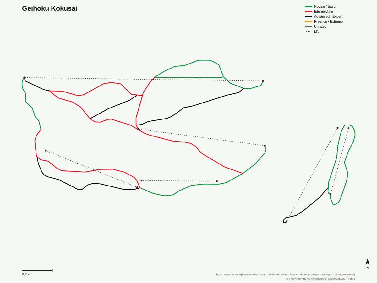
Geihoku Kokusai: 15 runs, 6 lifts. Drawn from OpenStreetMap run and lift data — not the official Geihoku Kokusai trail map. © OpenStreetMap contributors, OpenSkiMap (ODbL).
Typical conditions by month
Monthly conditions data for Geihoku Kokusai is not yet available.
Lift tickets & passes
Geihoku Kokusai has no multi-resort pass affiliations on record.
Getting there
Nearest airports
- Iwami Airport (IWJ) — 40.1 km straight-line
- Iwakuni Kintaikyo Airport (IWK) — 62.5 km straight-line
- Hiroshima Airport (HIJ) — 70.2 km straight-line
Nearest cities
- Hiroshima, Hiroshima — 39.9 km straight-line
- Hatsukaichi, Hiroshima — 41 km straight-line
- Higashihiroshima, Hiroshima — 57.3 km straight-line
Also covered by
Where to stay
A dedicated lodging guide for Geihoku Kokusai is not yet available.
Nearby resorts
- Osa Ski Resort — 4 km straight-line, 228.5 m vertical
- Utopia Saioto — 12 km straight-line, 405.9 m vertical
- Osorakan Snow Park — 15 km straight-line, 392.2 m vertical
- Mizuho Highland — 18 km straight-line, 721.4 m vertical
- Megahiraonsen Megahira Ski Area — 25 km straight-line, 472.3 m vertical
FAQ
- How far is Geihoku Kokusai from Hiroshima city?
- About 70.2 km to Hiroshima Airport and 39.9 km to Hiroshima city itself, close enough that the resort's own site markets the northern Geihoku ski area cluster as reachable within one to two hours from Hiroshima, enabling day trips.
- How big is Geihoku Kokusai?
- Vertical drop is 419.3 meters, from a 697.4-meter base to a 1,116.7-meter summit, with six chairlifts serving 15 runs across 9.77 kilometers.
- Is Geihoku Kokusai good for beginners?
- Novice terrain is the largest graded category at 3.36 km of the 9.77 km total, ahead of 3.44 km intermediate and 2.51 km advanced, with only 0.46 km rated easy — so beginner terrain here leans toward the novice classification specifically.
- When is Geihoku Kokusai's ski season?
- Resorts in the Geihoku cluster typically run December through March, with some opening as early as November using artificial snowmaking, per the area's own tourism information.
- What's the nearest airport to Geihoku Kokusai?
- Iwami Airport is closest at 40.1 km, though Hiroshima Airport, 70.2 km away, is the resort's listed regional gateway and the larger of the two.
- Which pass covers Geihoku Kokusai?
- Geihoku Kokusai has no multi-resort pass affiliations on record.
- Is Geihoku Kokusai good for a day trip from a big city?
- Yes — with Hiroshima, a city of over a million people, only about 40 km away, Geihoku Kokusai is positioned as one of the more accessible ski options for a metro area of that size in western Japan.
- How does Geihoku Kokusai compare to other Hiroshima Prefecture resorts?
- Its 419.3-meter vertical is the largest of the three Hiroshima resorts covered here, ahead of Osorakan Snow Park's 392.2 m and Utopia Saioto's 405.9 m, though Osorakan has more total run distance at 9.62 km against Geihoku Kokusai's 9.77 km — the two are close to tied on terrain volume.
Data sources
Last verified: 2026-09-15
Base facts from OpenSkiMap (ODbL), OpenStreetMap contributors, Wikidata (CC0), OurAirports (public domain) and GeoNames (CC BY 4.0). See /data-sources/.