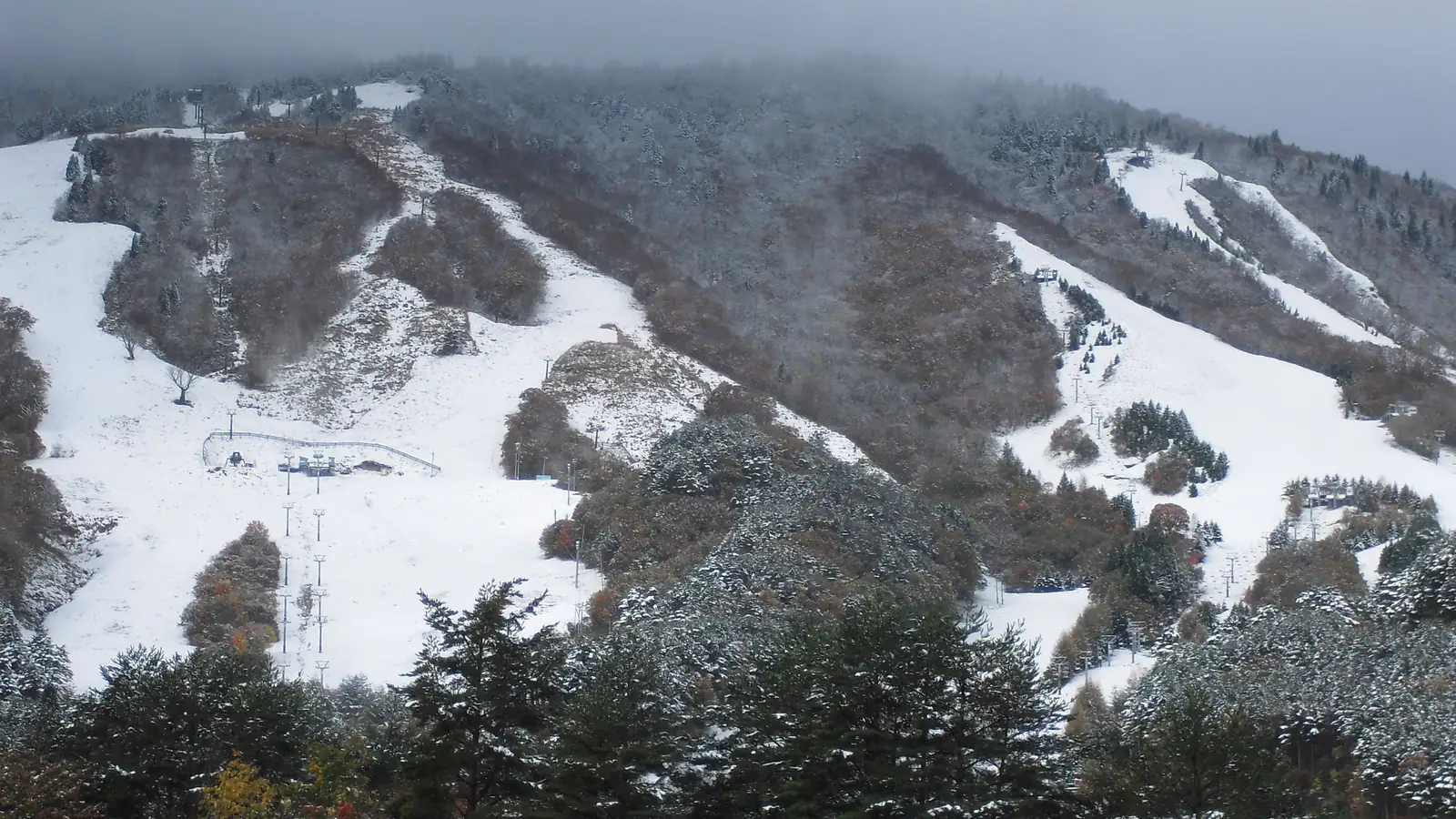
Osorakan Snow Park
Overview
Osorakan Snow Park sits on what its own site calls Hiroshima Prefecture’s highest peak, inside a designated quasi-national park area in Aki-Ota Town — a setting that gives it a different character from the other two Hiroshima-area resorts in this comparison set, Geihoku Kokusai and Utopia Saioto. Of the three, Osorakan carries both the largest terrain network and the steepest overall terrain profile: eight chairlifts serve 21 runs across 9.62 kilometers, more than double Saioto’s run distance and well ahead of Geihoku Kokusai’s, and advanced terrain leads the difficulty mix here at 4.19 km, the biggest single category on the mountain.
The rest of the terrain splits into 3.26 km easy, 1.91 km intermediate, and a thin 0.26 km novice — a distribution that puts real weight on both ends of the difficulty spectrum rather than concentrating skiers in the middle grades the way its regional neighbors tend to. Vertical drop is 392.2 meters, climbing from an 882-meter base to a 1,274.2-meter summit. In the warmer months, the same site converts to the Korokan Ecology Campground and runs forest therapy walks, taking advantage of the protected-area setting for a different kind of visitor entirely.
Access is comparable to the other Hiroshima resorts in this set: Hatsukaichi is the nearest city at 32.7 kilometers, with Hiroshima itself at 35.9 kilometers and Iwakuni at 48.9 kilometers, all within a manageable drive of a metro area of well over a million people. By air, Iwami Airport is closest at 33.2 kilometers, while Hiroshima Airport, the resort’s designated gateway, is farther out at 73.6 kilometers.
There’s no multi-resort pass tied to Osorakan Snow Park, so lift access is sold on its own. For skiers weighing the three Hiroshima Prefecture resorts covered here, Osorakan is the one to pick for the biggest terrain network and the most genuinely advanced skiing, while its national-park setting and dual-season ecology camp add a distinctly different off-season identity than a typical small Japanese ski area.
The resort’s run and lift positions are also mapped independently through OpenStreetMap and OpenSkiMap and listed on skimap.org, a useful cross-check given the limited detail available in English on the operator’s own site. Its eight-chairlift network works out to about 1.2 kilometers of trail per lift, sitting between the tighter, more compact layout at Utopia Saioto and the somewhat more spread-out network at Geihoku Kokusai — one more data point suggesting that within this small regional cluster, Osorakan strikes something of a middle ground on lift density even as it leads on total terrain and advanced-skiing share.
As with its regional neighbors, Hiroshima Airport is the only large airport among Osorakan’s three nearest options, with Iwami and Iwakuni Kintaikyo both medium facilities despite Iwami being the closer of the two. Hatsukaichi (114,173) and Hiroshima (1,200,754) are both within roughly 36 kilometers, giving Osorakan a similarly large potential day-trip population to draw on as its two Hiroshima Prefecture counterparts in this dataset. In imperial terms, its 392.2-meter vertical drop converts to roughly 1,287 feet, and advanced terrain makes up about 43.6% of total run distance, the largest difficulty share of any resort in this Hiroshima cluster, well ahead of easy terrain at 33.9% and intermediate at just under 20%.
Key stats
Official website — Last checked 2026-09-14
Lifts by type
| Type | Count |
|---|---|
| chair lift | 8 |
Runs by difficulty
| Difficulty | Distance |
|---|---|
| easy | 3.26 km |
| novice | 0.26 km |
| advanced | 4.19 km |
| intermediate | 1.91 km |
Maps
View official Osorakan Snow Park trail map (PDF) →
Run & lift overview
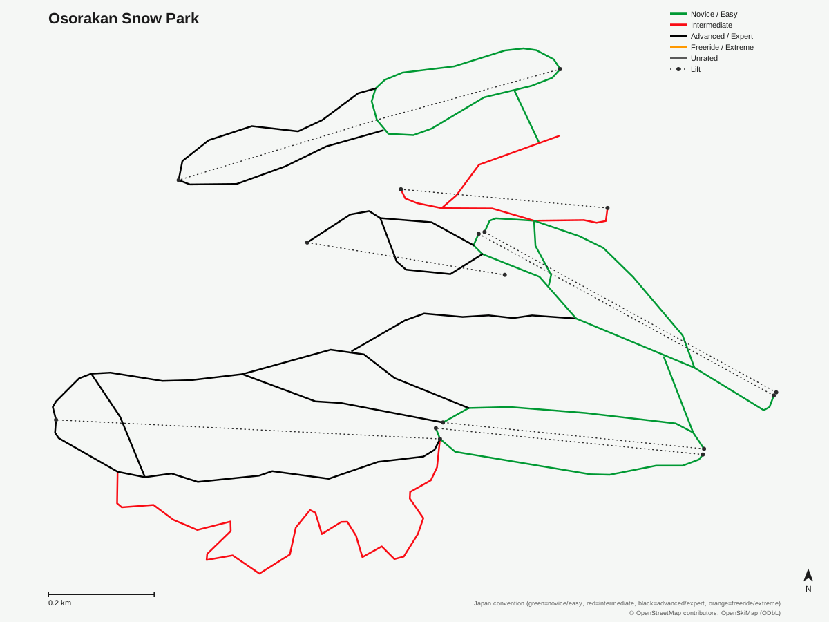
Osorakan Snow Park: 21 runs, 8 lifts. A schematic built from OpenStreetMap/OpenSkiMap data — this is not Osorakan Snow Park's official trail map. © OpenStreetMap contributors, OpenSkiMap (ODbL).
Typical conditions by month
Monthly conditions data for Osorakan Snow Park is not yet available.
Lift tickets & passes
Osorakan Snow Park has no multi-resort pass affiliations on record.
Getting there
Nearest airports
- Iwami Airport (IWJ) — 33.2 km straight-line
- Iwakuni Kintaikyo Airport (IWK) — 51.1 km straight-line
- Hiroshima Airport (HIJ) — 73.6 km straight-line
Nearest cities
- Hatsukaichi, Hiroshima — 32.7 km straight-line
- Hiroshima, Hiroshima — 35.9 km straight-line
- Iwakuni, Yamaguchi — 48.9 km straight-line
Also covered by
Where to stay
A dedicated lodging guide for Osorakan Snow Park is not yet available.
Nearby resorts
- Megahiraonsen Megahira Ski Area — 11 km straight-line, 472.3 m vertical
- Geihoku Kokusai — 15 km straight-line, 419.3 m vertical
- Osa Ski Resort — 18 km straight-line, 228.5 m vertical
- Utopia Saioto — 27 km straight-line, 405.9 m vertical
- Mizuho Highland — 32 km straight-line, 721.4 m vertical
FAQ
- Is Osorakan Snow Park on Hiroshima's highest mountain?
- The resort's own site describes it as sitting on Hiroshima Prefecture's highest peak, within a designated quasi-national park area, in Aki-Ota Town.
- How big is Osorakan Snow Park?
- Vertical drop is 392.2 meters, from an 882-meter base to a 1,274.2-meter summit, with eight chairlifts serving 21 runs across 9.62 kilometers — the largest terrain network of the three Hiroshima Prefecture resorts in this comparison set.
- Is Osorakan Snow Park good for advanced skiers?
- Yes — advanced terrain is the largest graded category at 4.19 km of the 9.62 km total, making Osorakan the most advanced-skewed of the three Hiroshima resorts covered here, ahead of 3.26 km easy, 1.91 km intermediate, and 0.26 km novice.
- What happens at Osorakan Snow Park in summer?
- The site switches to the Korokan Ecology Campground and offers forest therapy walks, running as a dual-season operation rather than shutting down outside winter.
- What's the nearest city to Osorakan Snow Park?
- Hatsukaichi is closest at 32.7 km, with Hiroshima city itself at 35.9 km and Iwakuni at 48.9 km.
- What's the nearest airport to Osorakan Snow Park?
- Iwami Airport is nearest at 33.2 km, though Hiroshima Airport, 73.6 km away, is the resort's listed regional gateway.
- Which pass covers Osorakan Snow Park?
- Osorakan Snow Park has no multi-resort pass affiliations on record.
- What's the lift setup at Osorakan Snow Park?
- All eight lifts are chairlifts, serving the resort's 21 runs at roughly 1.2 kilometers of trail per lift — tighter than Geihoku Kokusai's 1.63 km per lift but more generous than Utopia Saioto's 0.7 km per lift, the other two resorts in this same Hiroshima Prefecture cluster.
Data sources
Last verified: 2026-09-15
Base facts from OpenSkiMap (ODbL), OpenStreetMap contributors, Wikidata (CC0), OurAirports (public domain) and GeoNames (CC BY 4.0). See /data-sources/.