
Wakasa Hyonosen Ski Resort
Overview
Wakasa Hyonosen Ski Resort takes its name directly from the mountain it sits on, Mount Hyonosen in Tottori Prefecture, and runs a small but distinctly steep-leaning terrain network for its size. Five chairlifts serve 14 runs across a modest 4.09 kilometers of total distance, but the vertical drop packs in 417.2 meters, from a 770-meter base to a 1,187.2-meter summit — a ratio of vertical to run distance that points toward short, direct pitches rather than long groomed cruisers.
The terrain mix backs that up: 1.47 km is rated advanced, the largest single category, just ahead of 1.38 km intermediate and 1.12 km easy, with a small 0.12 km left ungraded. That’s an unusually even, steep-skewed split for a resort this size, where many small Japanese ski areas load up on beginner terrain instead. On site, the resort operates a mountain lodge called Alpine Hütte alongside its lift network, and it offers standard ski and snowboard rental and lesson services, though detailed English-language information about its history and terrain naming is limited.
Getting there means routing through the San’in region’s regional airports: Konotori Tajima Airport is the closest at 32.4 kilometers, with Tottori Sand Dunes Conan Airport close behind at 35.8 kilometers. Okayama Momotaro Airport, considerably farther at 87.7 kilometers, is the resort’s designated regional gateway, likely reflecting its larger scale and broader flight connections compared to the two nearer regional airports. On the ground, Tottori-shi is the nearest city of size at 28.8 kilometers, with Tsuyama (55.6 km) and Himeji (62.2 km) both over 50 kilometers out.
There’s no multi-resort pass tied to Wakasa Hyonosen, so a lift ticket is a standalone purchase. Given the resort’s small footprint and steep-skewed terrain split, it reads as a local, advanced-friendly mountain for the San’in coast rather than a beginner-focused destination or a multi-day trip in its own right — a reasonable stop for skiers already in the Tottori area rather than a primary reason to travel there.
The resort’s run and lift network is also documented independently on OpenStreetMap and OpenSkiMap and listed on skimap.org, useful given how little English-language descriptive material the resort’s own site otherwise offers. Its five-lift, all-chairlift setup keeps the terrain compact at roughly 0.82 kilometers of trail per lift, one of the tighter ratios among the small Japanese resorts covered in this dataset, and consistent with a mountain built around short, direct runs rather than long groomed descents.
Of the three nearest airports, only Okayama Momotaro is classed as a large airport; Konotori Tajima and Tottori Sand Dunes Conan are both medium facilities, which is likely why the resort’s listed gateway sits so much farther away than the two closer regional options. On population, Himeji (530,495) is by far the largest of the nearby cities, well ahead of Tottori-shi (188,465) and Tsuyama (102,294), even though it’s also the most distant of the three at over an hour’s drive. In imperial terms, the 417.2-meter vertical drop works out to roughly 1,369 feet — a genuinely respectable number for a resort running just five lifts and under 15 named runs.
Key stats
Official website — Last checked 2026-09-13
Lifts by type
| Type | Count |
|---|---|
| chair lift | 5 |
Runs by difficulty
| Difficulty | Distance |
|---|---|
| easy | 1.12 km |
| other | 0.12 km |
| advanced | 1.47 km |
| intermediate | 1.38 km |
Maps
View official Wakasa Hyonosen Ski Resort trail map (page) →
Run & lift overview
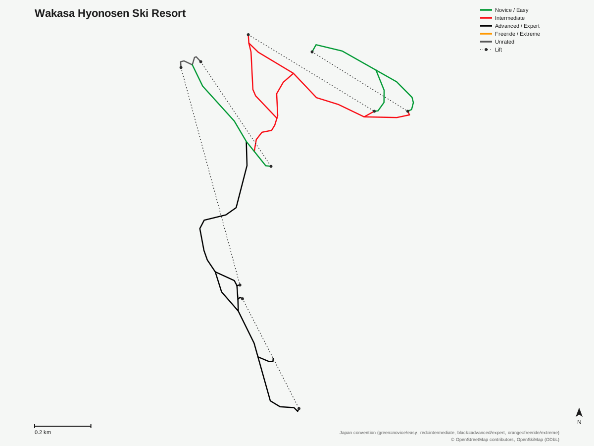
Wakasa Hyonosen Ski Resort: 14 runs, 5 lifts. Drawn from OpenStreetMap run and lift data — not the official Wakasa Hyonosen Ski Resort trail map. © OpenStreetMap contributors, OpenSkiMap (ODbL).
Typical conditions by month
Monthly conditions data for Wakasa Hyonosen Ski Resort is not yet available.
Lift tickets & passes
Wakasa Hyonosen Ski Resort has no multi-resort pass affiliations on record.
Getting there
Nearest airports
- Konotori Tajima Airport (TJH) — 32.4 km straight-line
- Tottori Sand Dunes Conan Airport (TTJ) — 35.8 km straight-line
- Okayama Momotaro Airport (OKJ) — 87.7 km straight-line
Nearest cities
- Tottori-shi, Tottori — 28.8 km straight-line
- Tsuyama, Okayama — 55.6 km straight-line
- Himeji, Hyōgo — 62.2 km straight-line
Also covered by
Where to stay
A dedicated lodging guide for Wakasa Hyonosen Ski Resort is not yet available.
Nearby resorts
- Hyounosen Kokusai Ski Resort — 4 km straight-line, 337 m vertical
- Hachikogen Ski Resort — 6 km straight-line, 360.4 m vertical
- Hachi Kita Ski Area — 7 km straight-line, 484.4 m vertical
- Banshu Tokura Snow Park — 8 km straight-line, 231 m vertical
- Hyper Bowl Tohachi — 8 km straight-line, 367.2 m vertical
FAQ
- How big is Wakasa Hyonosen Ski Resort?
- Vertical drop is 417.2 meters, from a 770-meter base to a 1,187.2-meter summit, with five chairlifts serving 14 runs across 4.09 kilometers.
- Is Wakasa Hyonosen good for advanced skiers?
- Advanced terrain is the largest graded category at 1.47 km of the 4.09 km total, just ahead of 1.38 km intermediate and 1.12 km easy — a small resort with a genuinely steep-leaning terrain mix rather than one built mainly for cruising.
- Where does Wakasa Hyonosen Ski Resort take its name from?
- The resort sits on the slopes of Mount Hyonosen in Tottori Prefecture and operates a mountain lodge called Alpine Hütte, per its own site.
- What's the nearest city to Wakasa Hyonosen Ski Resort?
- Tottori-shi is closest at 28.8 km, followed by Tsuyama at 55.6 km and Himeji at 62.2 km.
- What's the nearest airport to Wakasa Hyonosen Ski Resort?
- Konotori Tajima Airport is nearest at 32.4 km, though Okayama Momotaro Airport, 87.7 km away, is the resort's listed regional gateway.
- Which pass covers Wakasa Hyonosen Ski Resort?
- Wakasa Hyonosen has no multi-resort pass affiliations on record.
- Is Wakasa Hyonosen a large ski resort?
- No — at 4.09 km of total run distance across 14 runs, it's one of the smaller resorts in this comparison set, though its 417.2-meter vertical drop is respectable for its size.
- What's the lift setup at Wakasa Hyonosen Ski Resort?
- All five lifts are chairlifts, working out to about 0.82 kilometers of trail per lift across the resort's 14 runs — a tight, vertically dense layout rather than one built around long point-to-point cruising.
Data sources
Last verified: 2026-09-15
Base facts from OpenSkiMap (ODbL), OpenStreetMap contributors, Wikidata (CC0), OurAirports (public domain) and GeoNames (CC BY 4.0). See /data-sources/.