Hunter Mountain
Overview
Hunter Mountain trades on distance from New York City more than almost any other feature: the resort’s own marketing puts it at about two and a half hours from Manhattan, positioning it as the practical Catskills option for a city day-trip or overnight rather than a multi-day destination requiring a flight. Vail Resorts owns and operates it as part of a portfolio that spans North America and Australia, and the mountain sits on the Epic Pass and Epic Local Pass, both offering unlimited access with no blackout dates.
The mountain itself rises 467.0 vertical meters from a 501.9-meter base to a 968.9-meter summit, a modest elevation profile typical of the Catskills, served by 10 lifts, eight chairlifts plus a rope tow and a magic carpet, across 62 runs and 26.67 kilometers of terrain. Because natural snowfall this far south and at this elevation can be inconsistent, Hunter has built its reputation heavily around snowmaking capacity, a trait it shares with most of the region’s larger resorts but leans into more than most in its own promotional material.
Terrain skews toward the middle and upper end of the difficulty scale: 11.75 kilometers of intermediate runs leads, followed by 9.45 kilometers of advanced terrain and 5.02 kilometers easy, with a smaller stretch of other/ungraded terrain filling in the rest. That mix, combined with a large dedicated learning area for new skiers and riders, points to a mountain designed to handle a wide range of ability levels arriving from the city on any given weekend rather than one built around a narrow specialty.
Getting there means routing through the Hudson Valley or Capital Region: Albany International is closest at 69.7 kilometers, with New York Stewart International (78.1 km) and Bradley International near Hartford (129.7 km) as further options depending on where a trip starts. Albany itself, population around 101,000, sits 62.9 kilometers away, while Waterbury and North Stamford in Connecticut are both a bit farther at just over 120 kilometers.
Lift-to-terrain ratios put Hunter in the middle of the pack for Catskills resorts: 10 lifts across 62 runs works out to about 47 meters of vertical per lift and 0.43 kilometers per run on average, figures that support a mountain built for volume skiing on weekends rather than long, isolated descents. That’s consistent with a resort whose main draw is proximity to millions of New York City-area skiers rather than terrain scale, and it explains why heavy snowmaking investment, rather than natural snowfall or vertical drop, has become the resort’s defining operational focus.
As part of the Vail Resorts portfolio, Hunter Mountain sits alongside properties spanning North America and Australia, a scale of ownership that brings the Epic Pass and Epic Local Pass, both unlimited with no blackout dates, directly to a Catskills resort whose base elevation, 501.9 meters, is modest even by regional standards. That low base elevation is exactly why the resort’s own marketing leans so heavily on snowmaking capacity rather than natural snow character, since reliable coverage this far south and this low in elevation depends far more on infrastructure than it does on storm tracks. With a 968.9-meter summit and 62 runs spread across that modest vertical, Hunter still delivers meaningfully more terrain variety than its elevation numbers alone would suggest for a resort this close to New York City.
Key stats
Official website — Last checked 2026-09-13
Lifts by type
| Type | Count |
|---|---|
| rope tow | 1 |
| chair lift | 8 |
| magic carpet | 1 |
Runs by difficulty
| Difficulty | Distance |
|---|---|
| easy | 5.02 km |
| other | 0.45 km |
| advanced | 9.45 km |
| intermediate | 11.75 km |
Maps
View official Hunter Mountain trail map (PDF) →
Run & lift overview
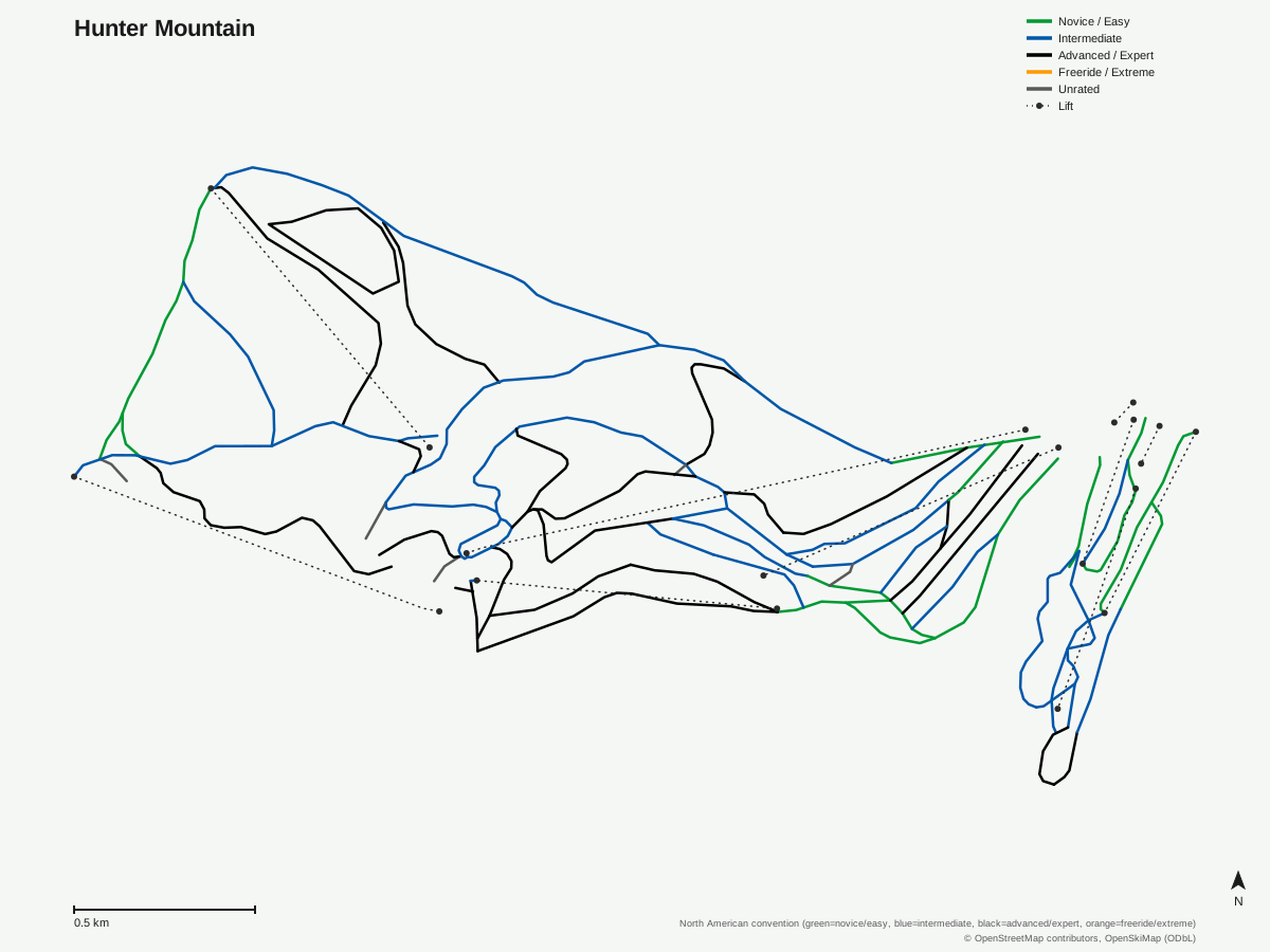
Hunter Mountain: 63 runs, 10 lifts. Generated from community-mapped OpenStreetMap data, not Hunter Mountain's official map artwork. © OpenStreetMap contributors, OpenSkiMap (ODbL).
Typical conditions by month
Monthly conditions data for Hunter Mountain is not yet available.
Lift tickets & passes
- Epic Pass — Unlimited, no blackout dates
- Epic Local Pass — Unlimited, no blackout dates
Getting there
Nearest airports
- Albany International Airport (ALB) — 69.7 km straight-line
- New York Stewart International Airport (SWF) — 78.1 km straight-line
- Bradley International Airport (BDL) — 129.7 km straight-line
Nearest cities
- Albany, New York — 62.9 km straight-line
- Waterbury, Connecticut — 120.2 km straight-line
- North Stamford, Connecticut — 130.9 km straight-line
Also covered by
Where to stay
A dedicated lodging guide for Hunter Mountain is not yet available.
Nearby resorts
- Belleayre Mountain Ski Center — 24 km straight-line, 418.9 m vertical
- Catamount Mountain Resort — 61 km straight-line, 293.2 m vertical
- Ski Butternut — 74 km straight-line, 284.6 m vertical
- Bousquet Mountain — 81 km straight-line, 210.6 m vertical
- Jiminy Peak Resort — 86 km straight-line, 340.9 m vertical
FAQ
- How far is Hunter Mountain from New York City?
- The resort markets itself as about two and a half hours from Manhattan, making it one of the more accessible Catskills ski areas for New York City residents.
- Who owns Hunter Mountain?
- Vail Resorts, which markets it alongside its wider North American and Australian portfolio.
- How big is Hunter Mountain?
- 467.0 vertical meters from a 968.9-meter summit to a 501.9-meter base, with 10 lifts (8 chairlifts, 1 rope tow, 1 magic carpet) serving 62 runs across 26.67 mapped kilometers.
- Is Hunter Mountain good for intermediate skiers?
- Intermediate terrain leads at 11.75 kilometers, ahead of 9.45 km advanced and 5.02 km easy, giving the mountain a clear middle-of-the-mountain focus.
- Is Hunter Mountain known for snowmaking?
- Yes, extensive snowmaking is one of the resort's core selling points, a common trait among Catskills resorts that need to guarantee coverage despite variable natural snowfall this far south.
- Which pass covers Hunter Mountain?
- Both the Epic Pass and Epic Local Pass include it with unlimited access and no blackout dates.
- What's the nearest airport to Hunter Mountain?
- Albany International, 69.7 kilometers away, is closest, with New York Stewart International (78.1 km) and Bradley International in Hartford (129.7 km) as other options.
- How long is the average run at Hunter Mountain, and does its trail map match the official run count?
- 26.67 kilometers across 62 runs works out to roughly 0.43 kilometers per run, with vertical per lift averaging about 47 meters across the 10-lift system; the resort's own piste map plots 63 routes against that official count of 62, a negligible gap that suggests the trail data is unusually well reconciled between sources.
Data sources
Last verified: 2026-09-17
Base facts from OpenSkiMap (ODbL), OpenStreetMap contributors, Wikidata (CC0), OurAirports (public domain) and GeoNames (CC BY 4.0). See /data-sources/.