Grand Targhee Resort
Overview
Grand Targhee occupies an unusual position for a resort so close to one of North America’s best-known ski towns: it sits on the western flank of the Teton Range, roughly 42 miles from Jackson as the crow flies, but reaching it from Jackson requires driving all the way around the mountains through Driggs, Idaho. Jackson Hole Airport is only about 26 km away in straight-line distance, yet the actual drive is considerably longer — a quirk of geography that keeps Grand Targhee quieter than its neighbor despite the proximity.
That western-slope position is also the source of the resort’s defining trait: snowfall. Grand Targhee sits directly in the path of Pacific moisture funneled east through a corridor in the Rockies, and the resort’s own figures put seasonal snowfall above 500 inches — a total that places it among the top handful of snowfall totals in North America. The terrain built around that snow spans 93 runs and 56.35 km, with a 681.7 m vertical drop from a 2,317.7 m base to a 2,999.4 m summit. The trail mix is heavily intermediate — 34.14 km of the resort’s total falls in that band, against 13.88 km of easy and 8.33 km of advanced terrain — a profile suited to skiers who want to spend a day working through deep, forgiving powder rather than hunting technical lines.
The resort opened December 26, 1969, developed initially by residents of eastern Idaho. Ownership passed to Bill Robinson in 1973, then to Mory and Carol Bergmeyer in 1987, before George Gillett’s company took over in 1997 and the Gillett family assumed full ownership in 2000 — a lineage of small, independent operators rather than a large multi-resort conglomerate, which is part of why Grand Targhee remains outside the major pass megaplexes. It does carry the Mountain Collective, which grants two no-blackout days here.
Six lifts, five chairs and a single magic carpet, cover the terrain. Beyond Jackson Hole Airport, Idaho Falls Regional (95 km) and Yellowstone Airport in West Yellowstone (101 km) offer alternative routes in, and Salt Lake City’s larger hub, at nearly 344 km, is a common option for travelers connecting from farther afield.
The intermediate-heavy terrain mix is a deliberate fit with the resort’s snow volume: with 500-plus inches falling most seasons, wide-open intermediate bowls hold and refresh powder more reliably than tightly gladed expert terrain, and Grand Targhee has built its reputation on exactly that combination — accessible pitch paired with reliably deep snow — rather than on the kind of technical extreme terrain that defines resorts like Crested Butte or Whitewater elsewhere in this group.
The ownership history also explains why Grand Targhee has stayed comparatively low-key despite its snow reputation. Unlike resorts absorbed into large multi-mountain pass conglomerates, Grand Targhee moved through a succession of individual and family owners — the original eastern Idaho developers, then Bill Robinson, then the Bergmeyers, then George Gillett’s company — before settling with the Gillett family since 2000. That kind of continuous small-ownership history is less common among North America’s snowiest resorts, many of which were bought out decades ago by larger operators chasing exactly the kind of reliable powder that put Grand Targhee on the map in the first place. The Mountain Collective affiliation is the resort’s only tie into a larger multi-resort pass network, a comparatively light footprint for a mountain with this level of snowfall renown.
Key stats
Official website — Last checked 2026-09-13
Lifts by type
| Type | Count |
|---|---|
| chair lift | 5 |
| magic carpet | 1 |
Runs by difficulty
| Difficulty | Distance |
|---|---|
| easy | 13.88 km |
| advanced | 8.33 km |
| intermediate | 34.14 km |
Maps
View official Grand Targhee Resort trail map (PDF) →
Run & lift overview
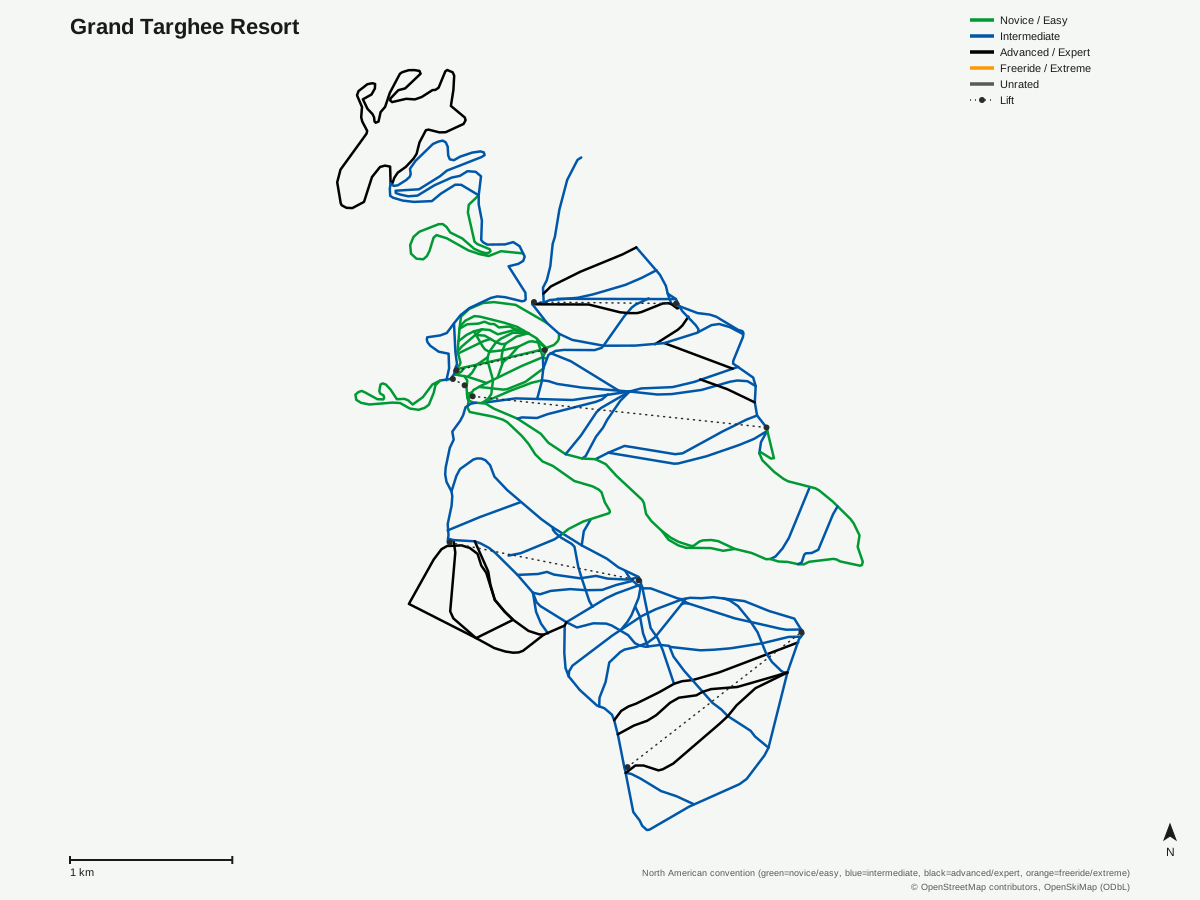
Grand Targhee Resort: 100 runs, 6 lifts. A schematic built from OpenStreetMap/OpenSkiMap data — this is not Grand Targhee Resort's official trail map. © OpenStreetMap contributors, OpenSkiMap (ODbL).
Typical conditions by month
Monthly conditions data for Grand Targhee Resort is not yet available.
Lift tickets & passes
- Mountain Collective — 2 days at this destination, no blackout dates
Getting there
Nearest airports
- Jackson Hole Airport (JAC) — 26.1 km straight-line
- Idaho Falls Regional Airport (IDA) — 95.3 km straight-line
- Yellowstone Airport (WYS) — 101.2 km straight-line
Nearest cities
- Billings, Montana — 294.3 km straight-line
- Salt Lake City, Utah — 345.3 km straight-line
- West Valley City, Utah — 354.9 km straight-line
Also covered by
Where to stay
A dedicated lodging guide for Grand Targhee Resort is not yet available.
Nearby resorts
- Jackson Hole Mountain Resort — 22 km straight-line, 1240.4 m vertical
- Snow King Mountain — 39 km straight-line, 514.4 m vertical
- Kelly Canyon Ski Resort — 57 km straight-line, 267.5 m vertical
- Sleeping Giant Winter Sports Area — 112 km straight-line, 241.1 m vertical
- White Pine Resort — 132 km straight-line, 273.8 m vertical
FAQ
- How big is Grand Targhee Resort?
- Grand Targhee has a 681.7 m vertical drop from a 2,317.7 m base to a 2,999.4 m summit, with 93 runs covering 56.35 km, served by six lifts.
- Is Grand Targhee Resort the same as Jackson Hole?
- No — the two are separate resorts on opposite sides of the Teton Range. Grand Targhee sits on the western slope near Alta, Wyoming, accessible only through Driggs, Idaho, while Jackson Hole is on the eastern side.
- Does Grand Targhee Resort get a lot of snow?
- Yes — the resort reports over 500 inches of snowfall per season, putting it among the snowiest ski areas in North America thanks to its position on the wetter west side of the Tetons.
- When did Grand Targhee Resort open?
- Grand Targhee opened on December 26, 1969, and has been owned by the Gillett family since 2000, following a series of ownership changes starting in 1973.
- Which pass covers Grand Targhee Resort?
- Grand Targhee is on the Mountain Collective, which grants two days of no-blackout access at the resort.
- What's the nearest airport to Grand Targhee Resort?
- Jackson Hole Airport (JAC) is closest at about 26 km, though reaching it from Grand Targhee means driving around the mountain range via Driggs, Idaho rather than a direct route.
- How many lifts does Grand Targhee Resort have?
- Six lifts serve the mountain: five chairlifts and a single magic carpet for the beginner learning zone.
- Is Grand Targhee Resort good for intermediate skiers?
- Yes — 34.14 km of the resort's 56.35 km of trail is rated intermediate, by far the largest category, well ahead of 13.88 km easy and 8.33 km advanced.
Data sources
Last verified: 2026-09-15
Base facts from OpenSkiMap (ODbL), OpenStreetMap contributors, Wikidata (CC0), OurAirports (public domain) and GeoNames (CC BY 4.0). See /data-sources/.