
Kijimadaira Ski Resort
Overview
Kijimadaira Ski Resort stands out among the Nagano Prefecture resorts in this comparison set mainly for its elevation profile: a 475.8-meter base, well below Madarao Kogen’s 917.8 meters or Kurohime Kogen’s 781.9 meters, the two other Nagano resorts covered here. That lower starting point still supports a real 385.6-meter vertical drop up to an 861.4-meter summit, and the resort packs an unusually high number of runs onto a modest lift network — 22 runs served by just five chairlifts, a higher run count relative to lift count than most comparably sized resorts nearby.
Total run distance comes to 8.23 kilometers, with intermediate terrain the largest share at 3.24 km, followed by 2.55 km easy, 0.87 km novice, and a thin 0.38 km advanced. That heavy lean toward intermediate and easy grading, combined with the relatively large number of distinct runs, suggests a mountain built around varied cruising terrain across a broad, moderate-pitch face rather than one offering much in the way of steep or technical skiing.
Nagano city sits 27.1 kilometers away, the closest population center of size, with Jōetsu (39.8 km) and Ueda (47.4 km) further out. Air access runs through Shinshu-Matsumoto Airport at 84.2 kilometers, though Niigata Airport, the resort’s designated regional gateway, is a considerably longer trip at 141 kilometers — a gap that means most visitors are more likely to arrive via Nagano’s road and rail network than fly directly into the nearer regional gateway.
There’s no multi-resort pass tied to Kijimadaira, so lift access is bought on its own rather than through a wider network. English-language detail on the resort’s history and on-mountain features is limited, so its profile here rests on the numbers: a lower-elevation, run-dense, intermediate-leaning mountain that fills a different niche from its higher, tree-run-focused Nagano neighbors in this dataset.
Kijimadaira’s run and lift network is also mapped independently on OpenStreetMap and OpenSkiMap and listed on skimap.org, offering a way to check current trail layout given how little else is published about the resort in English. Within this dataset’s Nagano Prefecture cluster, Kijimadaira stands out for run density rather than scale — its 22 runs are nearly triple Kurohime Kogen’s 12, even though its overall vertical drop and total run distance both trail the larger Madarao Kogen. That profile suggests a resort built around a wide variety of short, distinct named trails rather than a small number of long descents.
None of Kijimadaira’s three nearest airports rises above medium classification; its designated gateway, Niigata Airport, is a larger facility but sits considerably farther out at 141 kilometers. Nagano city’s population of 372,760 is again the dominant nearby population center, well ahead of Jōetsu (189,430) and Ueda (157,480), the same pattern seen across the other Nagano Prefecture resorts in this dataset. In imperial terms, Kijimadaira’s 385.6-meter vertical drop converts to roughly 1,265 feet, placing it within about 30 feet of Kurohime Kogen’s equivalent figure despite the two mountains’ very different run counts and total terrain volumes, a reminder that vertical drop alone doesn’t capture everything about how big a resort feels on the ground.
Key stats
Official website — Last checked 2026-09-13
Lifts by type
| Type | Count |
|---|---|
| chair lift | 5 |
Runs by difficulty
| Difficulty | Distance |
|---|---|
| easy | 2.55 km |
| other | 1.19 km |
| novice | 0.87 km |
| advanced | 0.38 km |
| intermediate | 3.24 km |
Maps
Official trail map: see kijimadaira.info
Run & lift overview
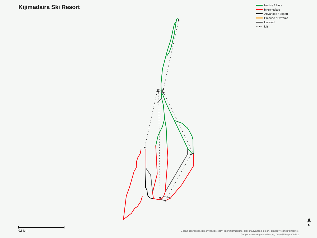
Kijimadaira Ski Resort: 22 runs, 5 lifts. Generated from community-mapped OpenStreetMap data, not Kijimadaira Ski Resort's official map artwork. © OpenStreetMap contributors, OpenSkiMap (ODbL).
Typical conditions by month
Monthly conditions data for Kijimadaira Ski Resort is not yet available.
Lift tickets & passes
Kijimadaira Ski Resort has no multi-resort pass affiliations on record.
Getting there
Nearest airports
- Shinshu-Matsumoto Airport (MMJ) — 84.2 km straight-line
- Toyama Kitokito Airport (TOY) — 110.1 km straight-line
- Sado Airport (SDS) — 138.2 km straight-line
Nearest cities
- Nagano, Nagano — 27.1 km straight-line
- Jōetsu, Niigata — 39.8 km straight-line
- Ueda, Nagano — 47.4 km straight-line
Also covered by
Where to stay
A dedicated lodging guide for Kijimadaira Ski Resort is not yet available.
Nearby resorts
- Makinoiri Kogen Snow Park — 1 km straight-line, 242.2 m vertical
- X-JAM Takaifuji — 2 km straight-line, 234.8 m vertical
- Yomase Onsen Ski Area — 3 km straight-line, 450.3 m vertical
- Kitashiga Komaruyama Ski Resort — 5 km straight-line, 315.5 m vertical
- Ryuoo Ski Park — 7 km straight-line, 1054.4 m vertical
FAQ
- How big is Kijimadaira Ski Resort?
- Vertical drop is 385.6 meters, from a 475.8-meter base to an 861.4-meter summit, with five chairlifts serving 22 runs across 8.23 kilometers.
- Is Kijimadaira a low-elevation resort?
- Relative to nearby Nagano Prefecture resorts, yes — its 475.8-meter base elevation is notably lower than Madarao Kogen's or Kurohime Kogen's, both of which sit at or above 780 meters.
- Is Kijimadaira good for intermediate skiers?
- Yes, intermediate terrain is the largest graded category at 3.24 km of the 8.23 km total, ahead of 2.55 km easy, 0.87 km novice, and a thin 0.38 km advanced.
- What's the nearest city to Kijimadaira Ski Resort?
- Nagano city is closest at 27.1 km, followed by Jōetsu at 39.8 km and Ueda at 47.4 km.
- What's the nearest airport to Kijimadaira Ski Resort?
- Shinshu-Matsumoto Airport is nearest at 84.2 km, though Niigata Airport, 141 km away, is the resort's listed regional gateway.
- Which pass covers Kijimadaira Ski Resort?
- Kijimadaira has no multi-resort pass affiliations on record.
- How many runs does Kijimadaira Ski Resort have?
- 22 runs across 8.23 kilometers, served by just five chairlifts — a higher run-to-lift ratio than most other small Nagano-area resorts in this comparison set.
- How does Kijimadaira compare to Kurohime Kogen?
- The two sit close on vertical drop — 385.6 m at Kijimadaira against 394.2 m at Kurohime — but Kijimadaira has nearly triple the run count, 22 versus 12, on one fewer lift, giving it a noticeably denser trail network for its size. Dividing 8.23 km across 22 runs also works out to an average of roughly 0.37 km per run, notably shorter than Madarao Kogen's average of about 0.44 km.
Data sources
Last verified: 2026-09-15
Base facts from OpenSkiMap (ODbL), OpenStreetMap contributors, Wikidata (CC0), OurAirports (public domain) and GeoNames (CC BY 4.0). See /data-sources/.