Yomase Onsen Ski Area
Overview
Yomase Onsen Ski Area doesn’t operate entirely as a standalone mountain. It’s paired with the neighboring X-JAM Takayama area under the shared marketing name Mt.KOSHA, with linking courses and lifts connecting the two so a single lift ticket covers both. On its own recorded terrain, Yomase Onsen runs 6 chairlifts across 11 runs and 7.43 kilometers, climbing 450.3 vertical meters from a 727.9-meter base to a 1,178.2-meter summit in Yamanouchi town, Nagano Prefecture.
The resort’s name comes directly from Yomase hot spring, part of the same stretch of Yamanouchi that’s long drawn onsen visitors alongside skiers, giving the area a dual identity as both a ski destination and a hot-spring town stop. That combination, easy-to-reach mountain skiing plus a soak afterward, is common across this part of Nagano but is written directly into this resort’s own name.
Terrain here is built overwhelmingly around the middle of the difficulty range: 6.49 kilometers of intermediate runs dwarfs the 0.82 kilometers of advanced and just 0.12 kilometers of easy terrain recorded on Yomase Onsen’s own side of the connected area. The resort’s own marketing echoes that split, describing itself as especially well-suited to entry-level and intermediate skiers rather than to experts chasing steep terrain, a positioning the run data supports even before factoring in the connected X-JAM Takayama side.
Access runs through central Nagano Prefecture: Nagano city, population around 372,800, is the closest major population center at just 25.5 kilometers, with Jōetsu (43.2 km) and Ueda (44.3 km) also within reach. Shinshu-Matsumoto Airport, 81.7 kilometers away, is the nearest airport, while Niigata Airport, 143.8 kilometers out, serves as the area’s more distant listed gateway for travelers coming from farther afield.
Six chairlifts is a small lift fleet by regional standards, and with no gondola or high-speed detachable listed, most laps here involve fixed-grip chairs rather than fast uphill transport. That fits a resort built for steady day-to-day skiing rather than one competing on lift infrastructure, and it keeps Yomase Onsen positioned as a straightforward, learner-friendly stop for visitors already spending time in the Nagano hot-spring towns rather than a headline destination in its own right.
The base-to-summit rise, 727.9 meters to 1,178.2 meters, is modest, and combined with the resort’s own emphasis on connecting to X-JAM Takayama for a wider combined terrain footprint, it’s clear the operators see the shared Mt.KOSHA branding as core to the resort’s appeal rather than treating Yomase Onsen as a standalone product. For a visitor planning around the intermediate-heavy 6.49 kilometers of graded terrain on Yomase Onsen’s own side, the practical takeaway is that a single lift ticket unlocks meaningfully more skiing than the 11-run, 7.43-kilometer figures for this side of the mountain alone would suggest. With six chairlifts and a 450.3-meter vertical drop feeding almost entirely intermediate terrain, the mountain reads as a low-risk, easy-to-navigate option for skiers who want to spend a full day building confidence rather than hunting for steep pitches, especially once the connected X-JAM Takayama runs are factored into the same day’s skiing on one ticket.
Key stats
Official website — Last checked 2026-09-13
Lifts by type
| Type | Count |
|---|---|
| chair lift | 6 |
Runs by difficulty
| Difficulty | Distance |
|---|---|
| easy | 0.12 km |
| advanced | 0.82 km |
| intermediate | 6.49 km |
Maps
View official Yomase Onsen Ski Area trail map (PDF) →
Run & lift overview
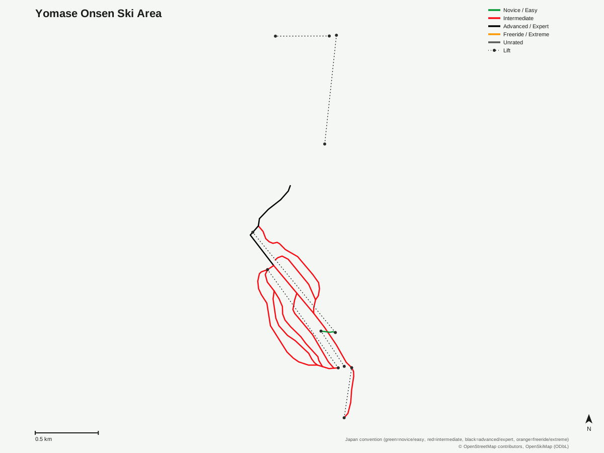
Yomase Onsen Ski Area: 11 runs, 6 lifts. Drawn from OpenStreetMap run and lift data — not the official Yomase Onsen Ski Area trail map. © OpenStreetMap contributors, OpenSkiMap (ODbL).
Typical conditions by month
Monthly conditions data for Yomase Onsen Ski Area is not yet available.
Lift tickets & passes
Yomase Onsen Ski Area has no multi-resort pass affiliations on record.
Getting there
Nearest airports
- Shinshu-Matsumoto Airport (MMJ) — 81.7 km straight-line
- Toyama Kitokito Airport (TOY) — 110.3 km straight-line
- Noto Satoyama Airport (NTQ) — 140.6 km straight-line
Nearest cities
- Nagano, Nagano — 25.5 km straight-line
- Jōetsu, Niigata — 43.2 km straight-line
- Ueda, Nagano — 44.3 km straight-line
Also covered by
Where to stay
A dedicated lodging guide for Yomase Onsen Ski Area is not yet available.
Nearby resorts
- X-JAM Takaifuji — 1 km straight-line, 234.8 m vertical
- Kijimadaira Ski Resort — 3 km straight-line, 385.6 m vertical
- Makinoiri Kogen Snow Park — 3 km straight-line, 242.2 m vertical
- Kitashiga Komaruyama Ski Resort — 4 km straight-line, 315.5 m vertical
- Ryuoo Ski Park — 5 km straight-line, 1054.4 m vertical
FAQ
- Is Yomase Onsen Ski Area connected to another resort?
- Yes, it operates jointly with the neighboring X-JAM Takayama area under the shared name Mt.KOSHA, with linking courses and lifts that let visitors ski both mountains on one lift ticket.
- How big is Yomase Onsen Ski Area?
- 450.3 vertical meters from a 1,178.2-meter summit to a 727.9-meter base, with 6 lifts, all chairlifts, serving 11 runs across 7.43 mapped kilometers on its own side of the connected area.
- Is Yomase Onsen Ski Area good for beginners?
- The resort markets itself as especially well-equipped for entry-level and intermediate skiers, and the data backs that up: intermediate terrain runs 6.49 kilometers, dwarfing the 0.82 km of advanced and 0.12 km of easy terrain recorded separately.
- What does the word Onsen mean in Yomase Onsen Ski Area?
- The name comes from Yomase hot spring (onsen), located in the same part of Yamanouchi town, Nagano Prefecture, where the ski area sits.
- What's the nearest airport to Yomase Onsen Ski Area?
- Shinshu-Matsumoto Airport, 81.7 kilometers away, ahead of Toyama Kitokito Airport at 110.3 kilometers.
- Which city is closest to Yomase Onsen Ski Area?
- Nagano city, with a population of roughly 372,800, is closest at 25.5 kilometers, putting the resort within easy reach of one of Nagano Prefecture's largest cities.
- How long is the average run at Yomase Onsen Ski Area?
- 7.43 kilometers across 11 runs works out to roughly 0.68 kilometers per run, with vertical per lift averaging about 75 meters across the six-lift system, both on the longer side for a resort this size.
Data sources
Last verified: 2026-09-17
Base facts from OpenSkiMap (ODbL), OpenStreetMap contributors, Wikidata (CC0), OurAirports (public domain) and GeoNames (CC BY 4.0). See /data-sources/.