China Peak Mountain Resort
Overview
China Peak Mountain Resort has carried three identities since it first opened in 1958 under founder Knut Flint, who built it to give San Joaquin Valley skiers a closer alternative to the drive up to Lake Tahoe. The resort took its original name from the adjacent Chinese Peak mountain, kept it through several ownership changes, then was rebranded Sierra Summit before the 1982-83 season after the Snow Summit company took over. New ownership under Tim Cohee restored the original China Peak name in 2010-2011, and the resort has run under that name since, most recently under owner Karl Kapuscinski since 2022.
That history includes a recent setback: the 2020 Creek Fire damaged sections of the resort, though operations resumed on schedule for the 2021-22 season, a recovery that reflects the resort’s position as one of relatively few lift-served options in the southern Sierra Nevada rather than a mountain that could easily be abandoned. Today the resort sits at Lakeshore, California on Highway 168, addressed to match its position near the water it’s named for.
The mountain rises 487.3 vertical meters from a 2,142.9-meter base to a 2,630.2-meter summit, with 11 lifts, a t-bar, six chairlifts, and four magic carpets, spread across 105 runs and 35.39 kilometers, among the largest run counts of any resort this size in the region. Terrain is heavily intermediate: 18.07 kilometers of intermediate runs is more than double the 6.9 kilometers of advanced terrain, with smaller pockets of easy (6.57 km), expert (2.34 km), novice (0.55 km), and freeride (0.71 km) terrain rounding out the mix.
China Peak sits on both the Indy Base Pass and the Indy+ Pass, each offering two all-day or all-night tickets per season, with the Indy+ version carrying no blackout dates. Access runs through the eastern Sierra: Mammoth Yosemite Airport is closest at 52.4 kilometers, with Fresno Yosemite International (70.6 km) handling more commercial traffic and Eastern Sierra Regional in Bishop (72.1 km) as a third option.
Averaged out, China Peak’s 35.39 kilometers across 105 counted runs works out to roughly 0.34 kilometers per run, and vertical per lift comes to about 44 meters across the 11-lift system, both figures pointing toward a densely lift-served mountain built for high lap counts rather than long point-to-point descents. That density has held through three different operating names and five separate ownership groups since 1958, a level of continuity in the underlying trail network that’s unusual given how often the resort’s branding and management have changed.
Today’s resort still operates from its original site at Lakeshore, California on Highway 168, with lodging available on the mountain through The Inn at China Peak for visitors who want to avoid the drive back down after a full day on the hill. The 2,142.9-meter base and 2,630.2-meter summit describe a mountain that founder Knut Flint built specifically as a closer alternative for San Joaquin Valley skiers back in 1958, a founding purpose the resort’s Highway 168 location, roughly 70.6 kilometers from Fresno’s airport, still reflects today.
Key stats
Official website — Last checked 2026-09-13
Lifts by type
| Type | Count |
|---|---|
| t-bar | 1 |
| chair lift | 6 |
| magic carpet | 4 |
Runs by difficulty
| Difficulty | Distance |
|---|---|
| easy | 6.57 km |
| other | 0.25 km |
| expert | 2.34 km |
| novice | 0.55 km |
| advanced | 6.9 km |
| freeride | 0.71 km |
| intermediate | 18.07 km |
Maps
View official China Peak Mountain Resort trail map (image) →

Run & lift overview
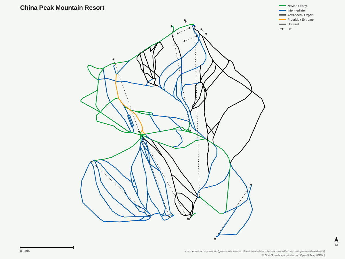
China Peak Mountain Resort: 114 runs, 11 lifts. A schematic built from OpenStreetMap/OpenSkiMap data — this is not China Peak Mountain Resort's official trail map. © OpenStreetMap contributors, OpenSkiMap (ODbL).
Typical conditions by month
Monthly conditions data for China Peak Mountain Resort is not yet available.
Lift tickets & passes
- Indy Base Pass — 2 All-Day or All-Night tickets per resort; blackout dates apply (exact 26/27 holiday blackout dates not yet finalized as of verified_date)
- Indy+ Pass — 2 All-Day or All-Night tickets per resort, no blackout dates
Getting there
Nearest airports
- Mammoth Yosemite Airport (MMH) — 52.4 km straight-line
- Fresno Yosemite International Airport (FAT) — 70.6 km straight-line
- Eastern Sierra Regional Airport (BIH) — 72.1 km straight-line
Nearest cities
- Clovis, California — 65.8 km straight-line
- Fresno, California — 76.2 km straight-line
- Visalia, California — 100.4 km straight-line
Also covered by
Where to stay
A dedicated lodging guide for China Peak Mountain Resort is not yet available.
Nearby resorts
- Mammoth Mountain — 48 km straight-line, 902.8 m vertical
- June Mountain — 59 km straight-line, 780.5 m vertical
- Dodge Ridge Ski Area — 127 km straight-line, 478.9 m vertical
- Bear Valley — 160 km straight-line, 558.7 m vertical
- Kirkwood Mountain Resort — 180 km straight-line, 504.9 m vertical
FAQ
- How old is China Peak Mountain Resort?
- It opened in 1958 under founder Knut Flint as China Peak, named for the adjacent mountain of the same name, making it one of the older ski areas in the southern Sierra Nevada.
- Why is China Peak sometimes called Sierra Summit?
- The Snow Summit company bought the resort and renamed it Sierra Summit before the 1982-83 season; the China Peak name was restored under new ownership in 2010-2011 and has stuck since.
- How big is China Peak Mountain Resort?
- 487.3 vertical meters from a 2,630.2-meter summit to a 2,142.9-meter base, with 11 lifts (1 t-bar, 6 chairlifts, 4 magic carpets) serving 105 runs across 35.39 mapped kilometers.
- Is China Peak good for intermediate skiers?
- Yes, intermediate terrain is by far the largest category at 18.07 kilometers, more than double the 6.9 km of advanced terrain, with smaller amounts of easy (6.57 km), expert (2.34 km), novice (0.55 km), and freeride (0.71 km) terrain.
- Did the Creek Fire affect China Peak?
- Yes, the 2020 Creek Fire damaged parts of the resort, though it resumed normal operations for the 2021-22 season.
- Which pass covers China Peak Mountain Resort?
- Both the Indy Base Pass and the Indy+ Pass include China Peak, each good for 2 all-day or all-night tickets per season; the Indy+ Pass carries no blackout dates.
- What's the nearest airport to China Peak Mountain Resort?
- Mammoth Yosemite Airport is closest at 52.4 kilometers, with Fresno Yosemite International, the larger commercial option, at 70.6 kilometers.
- How many runs does China Peak Mountain Resort's trail map show?
- The official piste map plots 114 routes, somewhat more than the 105 runs formally counted in the resort's own terrain statistics, a common gap between how trail maps and official run counts get tallied.
Data sources
Last verified: 2026-09-17
Base facts from OpenSkiMap (ODbL), OpenStreetMap contributors, Wikidata (CC0), OurAirports (public domain) and GeoNames (CC BY 4.0). See /data-sources/.