
Pajarito Mountain
Overview
Pajarito Mountain has operated on the north face of its namesake peak in the Jemez Mountains since November 23, 1957, when it opened as a modest local operation for Los Alamos County. Growth came in stages rather than all at once: the first chairlift arrived in 1969, and a new ski lodge wasn’t completed until 1988, a slower build-out typical of a resort run in large part by volunteers alongside its current operating partner, Mountain Capital Partners, across roughly 850 acres of privately owned land.
That community-driven character has been tested directly. The 2011 Las Conchas Fire, one of the largest wildfires in New Mexico history at the time, damaged facilities on the mountain, and yet Pajarito reopened for the following season rather than closing permanently, a recovery that says as much about the resort’s importance to Los Alamos as about the terrain itself.
Physically, the mountain rises 443.3 vertical meters from a 2,736.1-meter base to a 3,179.4-meter summit, with six lifts, five chairlifts and one magic carpet, serving 62 runs across 33.8 kilometers. Terrain leans toward the middle of the difficulty scale: 12.67 kilometers of intermediate runs is the largest category, ahead of 10.05 kilometers easy and 4.6 kilometers advanced, with 3.89 kilometers of expert terrain and a further 2.59 kilometers of other/ungraded runs rounding things out.
Getting to Pajarito means routing through northern New Mexico: Santa Fe Municipal Airport is closest at 41 kilometers, with Taos Regional (89.5 km) and Albuquerque International Sunport (96.6 km) as alternatives; Albuquerque doubles as both the nearest major airport option and the region’s largest nearby city, with a population over 564,000, at 92.7 kilometers from the mountain. That combination of local ownership, wildfire recovery, and a straightforward drive from Albuquerque or Santa Fe gives Pajarito a role closer to a community mountain than a marketed destination resort.
Terrain math reinforces that community-mountain read: six lifts across 62 runs works out to roughly 74 meters of vertical per lift and 0.55 kilometers per run on average, figures in line with a resort that grew in deliberate stages, first chairlift in 1969, new lodge in 1988, rather than being built out all at once by a single developer. Pueblo (306.7 km) and Colorado Springs (355.5 km), the next-listed cities after Albuquerque, are both well over 300 kilometers away, underscoring how much Pajarito depends on the Los Alamos and Santa Fe area rather than drawing from Colorado’s larger ski-trip market.
The mountain’s history reads as a long series of incremental steps rather than one large buildout: an opening day in November 1957, a first chairlift 12 years later in 1969, and a new lodge not completed until 1988, roughly three decades after the area first opened. That pace, combined with an ownership structure split between volunteers and Mountain Capital Partners and a base sitting at 2,736.1 meters, well above 8,900 feet, describes a resort shaped more by the steady commitment of a small community than by outside capital moving quickly to build out a destination resort, a pattern reinforced by how the mountain recovered from the 2011 Las Conchas Fire in time for the very next season. Six lifts and 62 runs across 443.3 vertical meters give Pajarito a genuinely varied terrain base for a community-operated area, with 3.89 kilometers of expert terrain offering more than a token challenge alongside the larger intermediate and easy categories, all served from a base that sits above 2,700 meters year after year.
Key stats
Official website — Last checked 2026-09-13
Lifts by type
| Type | Count |
|---|---|
| chair lift | 5 |
| magic carpet | 1 |
Runs by difficulty
| Difficulty | Distance |
|---|---|
| easy | 10.05 km |
| other | 2.59 km |
| expert | 3.89 km |
| advanced | 4.6 km |
| intermediate | 12.67 km |
Maps
View official Pajarito Mountain trail map (PDF) →
Run & lift overview
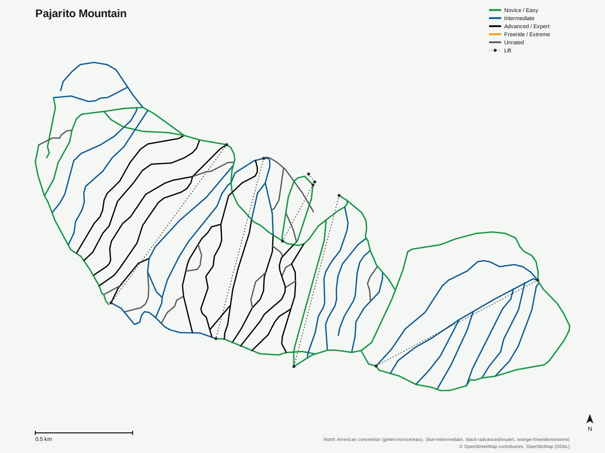
Pajarito Mountain: 62 runs, 6 lifts. Generated from community-mapped OpenStreetMap data, not Pajarito Mountain's official map artwork. © OpenStreetMap contributors, OpenSkiMap (ODbL).
Typical conditions by month
Monthly conditions data for Pajarito Mountain is not yet available.
Lift tickets & passes
Pajarito Mountain has no multi-resort pass affiliations on record.
Getting there
Nearest airports
- Santa Fe Municipal Airport (SAF) — 41 km straight-line
- Taos Regional Airport (TSM) — 89.5 km straight-line
- Albuquerque International Sunport (ABQ) — 96.6 km straight-line
Nearest cities
- Albuquerque, New Mexico — 92.7 km straight-line
- Pueblo, Colorado — 306.7 km straight-line
- Colorado Springs, Colorado — 355.5 km straight-line
Also covered by
Where to stay
A dedicated lodging guide for Pajarito Mountain is not yet available.
Nearby resorts
- Ski Santa Fe — 55 km straight-line, 534.4 m vertical
- Sandia Peak Ski Area — 77 km straight-line, 487.4 m vertical
- Sipapu Ski and Summer Resort — 81 km straight-line, 322.8 m vertical
- Taos Ski Valley — 114 km straight-line, 752.2 m vertical
- Angel Fire Resort — 116 km straight-line, 638.1 m vertical
FAQ
- How old is Pajarito Mountain?
- It first opened on November 23, 1957, with a first chairlift added in 1969 and a new ski lodge completed in 1988.
- Who owns Pajarito Mountain?
- The area is owned and operated by a combination of volunteers and Mountain Capital Partners, on roughly 850 acres of privately owned land west of Los Alamos.
- Did the Las Conchas Fire affect Pajarito Mountain?
- Yes, the 2011 Las Conchas Fire damaged facilities on the mountain, but the resort recovered and reopened the following season.
- How big is Pajarito Mountain?
- 443.3 vertical meters from a 3,179.4-meter summit to a 2,736.1-meter base, with 6 lifts (5 chairlifts, 1 magic carpet) serving 62 runs across 33.8 mapped kilometers.
- Is Pajarito Mountain good for intermediate skiers?
- Intermediate terrain leads at 12.67 kilometers, ahead of 10.05 km easy and 4.6 km advanced, with 3.89 km of expert terrain for more experienced skiers.
- Where is Pajarito Mountain located?
- On the north face of Pajarito Mountain in the Jemez Mountains, in Los Alamos County, New Mexico.
- What's the nearest airport to Pajarito Mountain?
- Santa Fe Municipal Airport, 41 kilometers away, is closest, though Albuquerque International Sunport, 96.6 kilometers out, is the resort's listed gateway airport.
- How long is the average run at Pajarito Mountain?
- 33.8 kilometers across 62 runs works out to roughly 0.55 kilometers per run, with vertical per lift averaging about 74 meters across the six-lift system.
Data sources
Last verified: 2026-09-17
Base facts from OpenSkiMap (ODbL), OpenStreetMap contributors, Wikidata (CC0), OurAirports (public domain) and GeoNames (CC BY 4.0). See /data-sources/.