
Hoodoo Ski Area
Overview
Hoodoo Ski Area calls itself Central Oregon’s original ski area, and it operates under a special-use permit from the Willamette National Forest rather than owning the land outright, a common arrangement for smaller Cascade Range resorts built on federal forest ground. That “original” framing gives Hoodoo a claim to regional seniority even as newer, larger destinations elsewhere in Oregon have grown around it.
The mountain covers 47 mapped runs and 20.48 kilometers of trail across a 300.6-meter vertical drop, from a 1,727.9-meter summit to a 1,427.3-meter base, served by six lifts, five chairlifts and a magic carpet. Easy terrain leads the difficulty breakdown at 9.85 kilometers, close to half the resort’s total distance, with 5.67 kilometers intermediate and 4.96 kilometers advanced, a spread that keeps Hoodoo approachable for families while still offering a meaningful chunk of harder terrain for more experienced skiers.
Beyond the standard lift-served slopes, Hoodoo lights select runs for night skiing and operates the Autobahn Tubing Park as a separate attraction, plus cross-country trails for Nordic skiers, giving the resort three distinct on-mountain experiences under one operation. An RFID lift ticket system speeds up access at the lifts, and the resort sells day passes, season passes, and a multi-day “AnyCard” option rather than relying on a single ticket type.
Hoodoo sits on both the Indy Base Pass and Indy+ Pass, each offering two all-day or all-night tickets per resort, giving pass holders a Cascades stop on an Indy-based multi-resort season. Roberts Field in Redmond, 60.5 kilometers away, is the closest airport, though Portland International, 143.2 kilometers out, handles most long-haul arrivals. Eugene, population roughly 176,654, is the nearest larger city at 103.8 kilometers, with Salem and Gresham both within a comparable driving distance, putting Hoodoo within reach of several mid-sized Willamette Valley population centers.
That Willamette Valley proximity is central to how Hoodoo positions itself: close enough to Eugene, Salem, and the wider valley corridor for a same-day round trip, while still sitting high enough in the Cascades, a 1,427.3-meter base rising to 1,727.9 meters, to hold snow reliably through a full winter. Night skiing extends that day-trip appeal into the evening for visitors who can’t get up the mountain until after work, and the combination of a tubing park and Nordic trails alongside the standard alpine terrain means a single Hoodoo visit can serve skiers, riders, tubers, and cross-country skiers from the same group without anyone having to drive to a separate facility. Hoodoo’s own marketing leans on being the closer, lower-hassle option for Willamette Valley residents rather than on chasing the largest vertical or trail count among Cascade Range ski areas. Operating under permit from the Willamette National Forest also ties the resort’s long-term footprint to federal land-management terms rather than to a private landowner’s own expansion plans, a constraint shared by many small Pacific Northwest ski areas built on national forest ground. Six lifts across 47 runs and 20.48 kilometers of trail works out to nearly 8 runs per lift, a genuinely broad spread of terrain relative to lift count for a resort of this size.
Key stats
Official website — Last checked 2026-09-13
Lifts by type
| Type | Count |
|---|---|
| chair lift | 5 |
| magic carpet | 1 |
Runs by difficulty
| Difficulty | Distance |
|---|---|
| easy | 9.85 km |
| advanced | 4.96 km |
| intermediate | 5.67 km |
Maps
View official Hoodoo Ski Area trail map (image) →

Run & lift overview
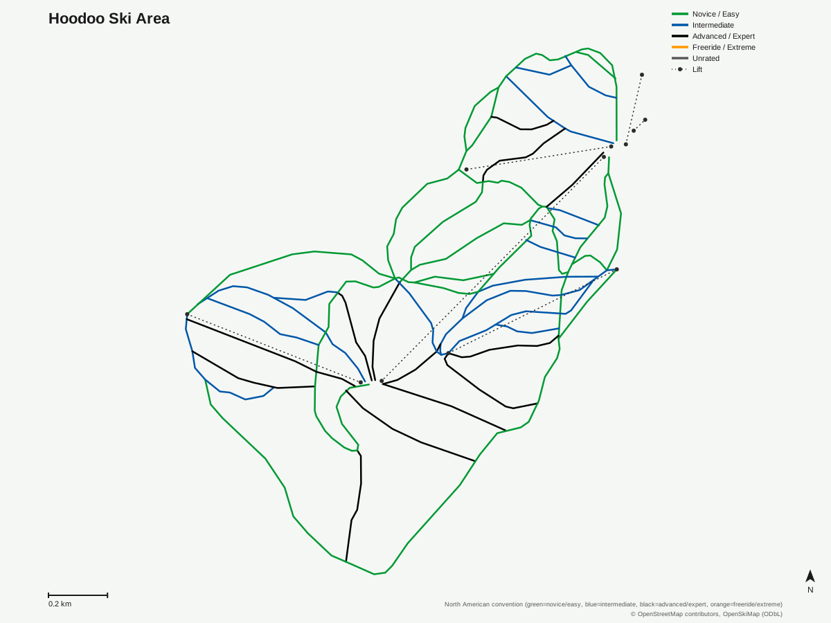
Hoodoo Ski Area: 47 runs, 6 lifts. Generated from community-mapped OpenStreetMap data, not Hoodoo Ski Area's official map artwork. © OpenStreetMap contributors, OpenSkiMap (ODbL).
Typical conditions by month
Monthly conditions data for Hoodoo Ski Area is not yet available.
Lift tickets & passes
- Indy Base Pass — 2 All-Day or All-Night tickets per resort; blackout dates apply (exact 26/27 holiday blackout dates not yet finalized as of verified_date)
- Indy+ Pass — 2 All-Day or All-Night tickets per resort, no blackout dates
Getting there
Nearest airports
- Roberts Field (RDM) — 60.5 km straight-line
- Salem-Willamette Valley Airport/McNary Field (SLE) — 105 km straight-line
- Eugene Airport (EUG) — 110.5 km straight-line
Nearest cities
- Eugene, Oregon — 103.8 km straight-line
- Salem, Oregon — 109.1 km straight-line
- Gresham, Oregon — 129 km straight-line
Also covered by
Where to stay
A dedicated lodging guide for Hoodoo Ski Area is not yet available.
Nearby resorts
- Mt. Bachelor — 48 km straight-line, 985.9 m vertical
- Willamette Pass — 89 km straight-line, 474.4 m vertical
- Mt. Hood Skibowl — 99 km straight-line, 415.7 m vertical
- Timberline Lodge Ski Area — 103 km straight-line, 1371 m vertical
- Mt. Hood Meadows Ski Resort — 105 km straight-line, 845.8 m vertical
FAQ
- Is Hoodoo the oldest ski area in Central Oregon?
- Hoodoo describes itself as Central Oregon's original ski area, operating under a special-use permit with the Willamette National Forest on land it does not own outright.
- How big is Hoodoo Ski Area?
- The resort drops 300.6 vertical meters from a 1,727.9-meter summit to a 1,427.3-meter base, with 6 lifts (5 chairlifts and a magic carpet) serving 47 mapped runs across 20.48 kilometers of trail.
- Is Hoodoo good for beginners?
- Easy terrain is the largest category at 9.85 kilometers, nearly half the resort's 20.48 kilometers, with 5.67 kilometers intermediate and 4.96 kilometers advanced covering the rest.
- Does Hoodoo offer night skiing?
- Yes, the resort lights a portion of its runs for night skiing, extending the ski day into the evening.
- Does Hoodoo have a tubing hill?
- Yes, the resort operates the Autobahn Tubing Park as a dedicated snow-tubing area alongside its lift-served alpine terrain and cross-country Nordic trails, giving non-skiers in a group something to do on the same visit.
- Is Hoodoo on the Indy Pass?
- Yes. Both the Indy Base Pass and Indy+ Pass include Hoodoo, each with two all-day or all-night tickets per resort, with the Indy+ tier carrying no blackout dates.
- What's the nearest city to Hoodoo?
- Eugene, Oregon, population around 176,654, is the nearest larger city at 103.8 kilometers, with Salem close behind at 109.1 kilometers.
- What's the nearest airport to Hoodoo?
- Roberts Field in Redmond is closest at 60.5 kilometers, with Portland International Airport, the region's main gateway, farther out at 143.2 kilometers.
Data sources
Last verified: 2026-09-17
Base facts from OpenSkiMap (ODbL), OpenStreetMap contributors, Wikidata (CC0), OurAirports (public domain) and GeoNames (CC BY 4.0). See /data-sources/.